|
search place name
|
||
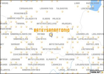
Batey San Antonio (Monte Plata, Dominican Republic)Batey San Antonio is a town in the Monte Plata region of Dominican Republic. An overview map of the region around Batey San Antonio is displayed below.
regional and 3d topo map of Batey San Antonio, Dominican Republic ::
Batey San Antonio airports ::
The nearest airport is SDQ - Santo Domingo Las Americas Intl, located 68.8 km south of Batey San Antonio.
Other airports nearby include STI - Santiago Cibao Intl (87.2 km north west), POP - Puerto Plata Gregorio Luperon Intl (109.3 km north west), LRM - La Romana Casa De Campo Intl (120.1 km south east), BRX - Barahona Maria Montez Intl (155.6 km south west), Nearby towns ::
Palmar Viejo (1.9km north) //
Batey Zapote (1.8km east) //
Francisquito (2.6km north east) //
Batey Altagracia (3.5km east) //
Batey Luna (3.5km west) //
Payabo (3.5km west) //
Batey Buena Vista (3.5km west) //
Chamuscada (3.5km west) //
Batey Rincón Claro (4.1km north west) //
Batey San José (4.1km south east) //
Las Yayas (4.0km south west) //
Batey Esperanza (4.0km south west) //
Arroyo El Naranjo (5.1km north west) //
Batey Ara (5.1km south east) //
Los Guineos (5.1km south west) //
Batey Santa Rosa (5.6km south) //
La Abadesa (5.3km west) //
Valle Grande (5.6km west) //
Rincón Solo (5.6km east) //
Palacio (5.8km north) //
Batey Piraco (5.6km east) //
El Bono (5.8km north) //
Balsa Mala (6.4km north east) //
Majagual (6.4km north east) //
Hato San Pedro (6.6km south west) //
Batey Piedra (6.6km north west) //
Batey Nuevo (7.0km east) //
Cayacoa (7.2km east) //
Batey Sabana Larga de Cojobal (7.6km south) //
[all distances 'as the bird flies' and approximate]  Places with similar names to Batey San Antonio, Dominican Republic :: Disclaimer :: Information on this page comes without warranty of any kind |
||
|
Where is Batey San Antonio? Elevation and coordinates ::
Latitude (lat): 19°1'0"N Longitude (lon): 69°53'0"W
Elevation (approx.): 161m (map arrows pan, magnifying glasses zoom) |
||
|
Visiting Batey San Antonio? Hotel/Accommodation ::
Book a hotel in Batey San Antonio Travel Guide ::
rental cars ::
car rental offers GPS waypoint ::
download a GPX waypoint (PoI) of Batey San Antonio for your GPS receiver
|
||