|
search place name
|
||
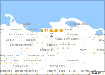
Bayaguana (El Seíbo, Dominican Republic)Bayaguana is a town in the El Seíbo region of Dominican Republic. An overview map of the region around Bayaguana is displayed below.
regional and 3d topo map of Bayaguana, Dominican Republic ::
Bayaguana airports ::
The nearest airport is LRM - La Romana Casa De Campo Intl, located 57.9 km south of Bayaguana.
Other airports nearby include PUJ - Punta Cana Intl (80.4 km south east), SDQ - Santo Domingo Las Americas Intl (92.3 km south west), STI - Santiago Cibao Intl (175.6 km west), POP - Puerto Plata Gregorio Luperon Intl (186.8 km north west), Nearby towns ::
Cocoloco (1.9km north) //
Los Cuatro Caminos (1.8km west) //
La Mina (1.8km east) //
El Perro (1.8km west) //
El Hato (1.9km south) //
El Amarradero (2.6km south west) //
Rufino (2.6km south west) //
El Javillar (2.6km south west) //
Río Arriba (3.7km south) //
Capuá (3.7km south) //
La Cuchilla (4.0km south west) //
El Colorado (4.0km south east) //
Altamira (4.0km south east) //
Los Guayacanes (4.1km south east) //
Cuarón (5.1km south east) //
Las Tres Palmas (5.1km south west) //
Icacos Blancos (5.3km east) //
El Grigrí (5.3km west) //
Los Higos (5.6km east) //
Miches (5.6km west) //
Sabana de Los Franceses (5.6km west) //
Sabana Los Mosquiticos (5.6km east) //
Paso de Luis Félix (5.6km west) //
La Montera (5.8km south) //
Las Cabirmas (5.8km south) //
Los Mosquitos (6.4km south east) //
Los Urabos (7.0km east) //
Canta Maco (7.0km west) //
El Guaraguao (7.0km east) //
[all distances 'as the bird flies' and approximate]  Places with similar names to Bayaguana, Dominican Republic ::
Disclaimer :: Information on this page comes without warranty of any kind |
||
|
Where is Bayaguana? Elevation and coordinates ::
Latitude (lat): 18°58'0"N Longitude (lon): 69°0'0"W
Elevation (approx.): 15m (map arrows pan, magnifying glasses zoom) |
||
|
Visiting Bayaguana? Hotel/Accommodation ::
Book a hotel in Bayaguana Travel Guide ::
rental cars ::
car rental offers GPS waypoint ::
download a GPX waypoint (PoI) of Bayaguana for your GPS receiver
|
||