|
search place name
|
||
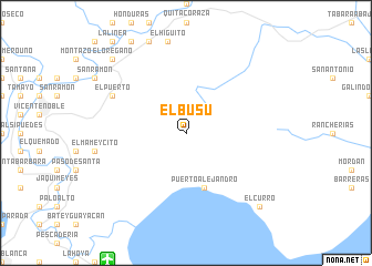
El Busú (Barahona, Dominican Republic)El Busú is a town in the Barahona region of Dominican Republic. An overview map of the region around El Busú is displayed below.
regional and 3d topo map of El Busú, Dominican Republic ::
El Busú airports ::
The nearest airport is BRX - Barahona Maria Montez Intl, located 14.8 km south west of El Busú.
Other airports nearby include STI - Santiago Cibao Intl (124.3 km north), PAP - Port-au-prince Toussaint Louverture Intl (133.3 km west), SDQ - Santo Domingo Las Americas Intl (146.1 km east), POP - Puerto Plata Gregorio Luperon Intl (162.1 km north), Nearby towns ::
Puerto Alejandro (5.8km south) //
El Puerto (8.0km north west) //
El Orégano (10.2km north west) //
Fondo Negro (10.2km north west) //
El Curro (10.2km south east) //
[all distances 'as the bird flies' and approximate] 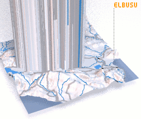 Places with similar names to El Busú, Dominican Republic ::
// Elibuše (BA)
// Elbaşı (TR)
// Ellibaş (TR)
// El Abassia (TN)
// El Bozo (MX)
// El Boussaï (MR)
// El Bos (MA)
// El Abosa (ET)
Disclaimer :: Information on this page comes without warranty of any kind |
||
|
Where is El Busú? Elevation and coordinates ::
Latitude (lat): 18°22'0"N Longitude (lon): 71°3'0"W
Elevation (approx.): 1027m (map arrows pan, magnifying glasses zoom) |
||
|
Visiting El Busú? Hotel/Accommodation ::
Book a hotel in El Busú Travel Guide ::
rental cars ::
car rental offers GPS waypoint ::
download a GPX waypoint (PoI) of El Busú for your GPS receiver
|
||