|
search place name
|
||
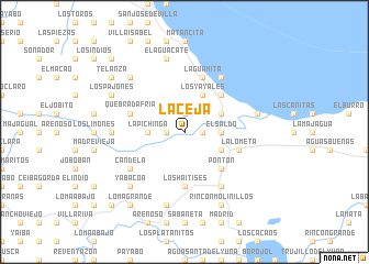
La Ceja (María Trinidad Sánchez, Dominican Republic)La Ceja is a town in the María Trinidad Sánchez region of Dominican Republic. An overview map of the region around La Ceja is displayed below.
regional and 3d topo map of La Ceja, Dominican Republic ::
La Ceja airports ::
The nearest airport is STI - Santiago Cibao Intl, located 84.2 km west of La Ceja.
Other airports nearby include SDQ - Santo Domingo Las Americas Intl (93.9 km south), POP - Puerto Plata Gregorio Luperon Intl (96.0 km north west), LRM - La Romana Casa De Campo Intl (131.3 km south east), PUJ - Punta Cana Intl (171.5 km south east), Nearby towns ::
Ceja de la Guamita (1.9km north) //
La Ceja de la Palma (1.7km west) //
Ceja del Jobo (1.7km east) //
El Papayo (3.5km west) //
La Pichinga (3.5km west) //
El Naranjo (3.5km east) //
El Saldo (3.5km east) //
El Machete (3.5km east) //
Los Yayales (4.1km north east) //
El Anón (4.0km north east) //
Caño Abajo (4.0km south east) //
Caño Mai Tomasina (4.0km south east) //
Cruce de Rincón (4.0km south east) //
El Tope del Yayal (5.1km north east) //
El Pozo (5.1km south east) //
Pontón (5.1km south east) //
Los Haitises (5.6km south) //
Quebrada Fría (5.6km west) //
La Cimarra (5.6km west) //
La Lometa (5.6km east) //
La Guamita (5.8km north) //
Candela (6.4km south west) //
Las Garzas (6.6km south east) //
El Cruce (6.6km north east) //
Colorado (6.6km north east) //
El Pozo (7.0km west) //
El Aguacate (7.6km north) //
Ceja de la Culebra (7.2km east) //
El Aguacate (7.6km south) //
[all distances 'as the bird flies' and approximate]  Places with similar names to La Ceja, Dominican Republic ::
Disclaimer :: Information on this page comes without warranty of any kind |
||
|
Where is La Ceja? Elevation and coordinates ::
Latitude (lat): 19°16'0"N Longitude (lon): 69°49'0"W
Elevation (approx.): 6m (map arrows pan, magnifying glasses zoom) |
||
|
Visiting La Ceja? Hotel/Accommodation ::
Book a hotel in La Ceja Travel Guide ::
rental cars ::
car rental offers GPS waypoint ::
download a GPX waypoint (PoI) of La Ceja for your GPS receiver
|
||