|
search place name
|
||
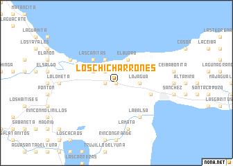
Los Chicharrones (Samaná, Dominican Republic)Los Chicharrones is a town in the Samaná region of Dominican Republic. An overview map of the region around Los Chicharrones is displayed below.
regional and 3d topo map of Los Chicharrones, Dominican Republic ::
Los Chicharrones airports ::
The nearest airport is SDQ - Santo Domingo Las Americas Intl, located 90.8 km south of Los Chicharrones.
Other airports nearby include STI - Santiago Cibao Intl (98.3 km west), POP - Puerto Plata Gregorio Luperon Intl (108.7 km north west), LRM - La Romana Casa De Campo Intl (120.2 km south east), PUJ - Punta Cana Intl (158.3 km south east), Nearby towns ::
Cruce La Majagua (0.0km north) //
Aguas Buenas (0.0km north) //
El Catey (1.7km west) //
Piedras Quemadas (1.7km west) //
Guachupita (1.7km west) //
La Majagua (2.5km north west) //
La Canoa (3.5km east) //
La Jagua (3.5km east) //
El Burro (4.1km north east) //
Jackson (4.1km north west) //
El Escarbado (4.0km north west) //
Las Cañitas (5.1km north west) //
Los Mangos (5.6km east) //
La Balsa (6.6km south east) //
La Mata (7.6km south) //
Ceja de la Culebra (7.9km north west) //
[all distances 'as the bird flies' and approximate] 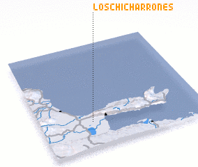 Places with similar names to Los Chicharrones, Dominican Republic ::
// Los Cucharones (VE)
// Los Chicharrones (DO)
// Los Chicharrones (DO)
// Los Chicharrones (DO)
// Los Chicharrones (DO)
// Los Chicharrones (DO)
Disclaimer :: Information on this page comes without warranty of any kind |
||
|
Where is Los Chicharrones? Elevation and coordinates ::
Latitude (lat): 19°15'0"N Longitude (lon): 69°41'0"W
Elevation (approx.): 57m (map arrows pan, magnifying glasses zoom) |
||
|
Visiting Los Chicharrones? Hotel/Accommodation ::
Book a hotel in Los Chicharrones Travel Guide ::
rental cars ::
car rental offers GPS waypoint ::
download a GPX waypoint (PoI) of Los Chicharrones for your GPS receiver
|
||