|
search place name
|
||
Majagual (Duarte, Dominican Republic)Majagual is a town in the Duarte region of Dominican Republic. An overview map of the region around Majagual is displayed below.
regional and 3d topo map of Majagual, Dominican Republic ::

Majagual airports ::
The nearest airport is STI - Santiago Cibao Intl, located 68.8 km west of Majagual.
Other airports nearby include POP - Puerto Plata Gregorio Luperon Intl (83.5 km north west), SDQ - Santo Domingo Las Americas Intl (97.8 km south), LRM - La Romana Casa De Campo Intl (143.2 km south east), BRX - Barahona Maria Montez Intl (165.6 km south west), Nearby towns ::
Cinta Negra (1.9km north) //
Higüero (1.7km east) //
Jina Clara (2.5km south west) //
El Helechal (2.5km north east) //
Firme Las Taranas (2.5km south east) //
El Papayo (3.5km east) //
Arenoso (3.5km east) //
Arroyo Claro (4.1km north west) //
Cuesta Blanca (4.0km south west) //
La Joya (4.1km south west) //
Los Palmaritos (4.1km south west) //
El Jobito (4.0km north east) //
La Garata (5.1km south west) //
Jobo Dulce (5.6km south) //
Baiguate (5.6km south) //
Yaiba Arriba (5.8km south) //
Yanabo (5.8km south) //
Ceiba Gorda (5.8km south) //
Alto del Rancho (5.8km north) //
El Campamento (5.6km east) //
Yaiba Abajo (6.6km south west) //
Curazao (6.6km south west) //
La Peonía (6.4km north east) //
Los Cafeces (6.4km south west) //
El Macao (6.6km north east) //
Jobobán (6.4km south east) //
Los Guaraguaos (7.0km west) //
El Rucio (7.0km west) //
Los Limones (7.0km east) //
[all distances 'as the bird flies' and approximate] 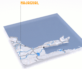 Places with similar names to Majagual, Dominican Republic ::
Disclaimer :: Information on this page comes without warranty of any kind |
||
|
Where is Majagual? Elevation and coordinates ::
Latitude (lat): 19°16'0"N Longitude (lon): 69°58'0"W
Elevation (approx.): 314m (map arrows pan, magnifying glasses zoom) |
||
|
Visiting Majagual? Hotel/Accommodation ::
Book a hotel in Majagual Travel Guide ::
rental cars ::
car rental offers GPS waypoint ::
download a GPX waypoint (PoI) of Majagual for your GPS receiver
|
||