|
search place name
|
||
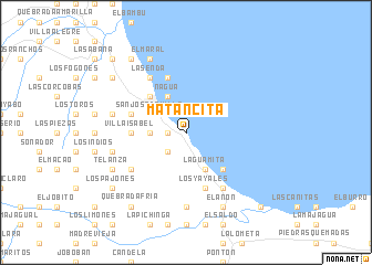
Matancita (María Trinidad Sánchez, Dominican Republic)Matancita is a town in the María Trinidad Sánchez region of Dominican Republic. An overview map of the region around Matancita is displayed below.
regional and 3d topo map of Matancita, Dominican Republic ::
Matancita airports ::
The nearest airport is STI - Santiago Cibao Intl, located 83.0 km west of Matancita.
Other airports nearby include POP - Puerto Plata Gregorio Luperon Intl (91.0 km north west), SDQ - Santo Domingo Las Americas Intl (103.1 km south), LRM - La Romana Casa De Campo Intl (137.8 km south east), PUJ - Punta Cana Intl (175.9 km south east), Nearby towns ::
La Amarga (1.7km west) //
El Aguacate (2.5km south west) //
La Cruz (3.5km west) //
Nagua (4.1km north west) //
El Manguito (4.0km north west) //
San José de Villa (4.0km north west) //
La Guamita (4.1km south east) //
La Capitalita (5.1km north west) //
Colorado (5.1km south east) //
El Cruce (5.1km south east) //
Villa Isabel (5.2km west) //
El Estero (5.8km north) //
El Guayo (5.6km west) //
Los Yayales (5.8km south) //
La Senda (6.6km north west) //
El Barro (6.4km south west) //
El Tope del Yayal (6.6km south east) //
Ceja de la Guamita (7.4km south) //
Los Cacaítos (7.2km west) //
El Blanco (7.2km west) //
Piedra Blanca (7.9km south west) //
El Factor (7.9km south west) //
Telanza (7.9km south west) //
Boca Vieja (8.2km north west) //
El Maral (8.2km north west) //
El Anón (8.2km south east) //
Cruce El Caño (8.9km north west) //
La Sabaneta (8.9km north west) //
Los Pajones (8.9km south west) //
[all distances 'as the bird flies' and approximate] 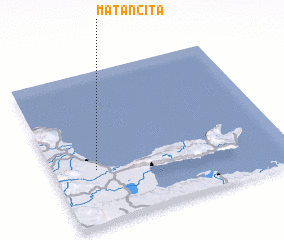 Places with similar names to Matancita, Dominican Republic ::
// Matancita (MX)
// Matancita (MX)
// Meydān-e Āzādī (IR)
// Madina Sadda (GM)
// Medina Sedia (GM)
// Matnäset (SE)
Disclaimer :: Information on this page comes without warranty of any kind |
||
|
Where is Matancita? Elevation and coordinates ::
Latitude (lat): 19°21'0"N Longitude (lon): 69°49'0"W
Elevation (approx.): 6m (map arrows pan, magnifying glasses zoom) |
||
|
Visiting Matancita? Hotel/Accommodation ::
Book a hotel in Matancita Travel Guide ::
rental cars ::
car rental offers GPS waypoint ::
download a GPX waypoint (PoI) of Matancita for your GPS receiver
|
||