|
search place name
|
||
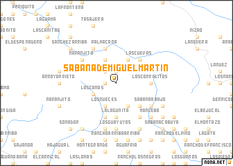
Sabana de Miguel Martín (Azua, Dominican Republic)Sabana de Miguel Martín is a town in the Azua region of Dominican Republic. An overview map of the region around Sabana de Miguel Martín is displayed below.
regional and 3d topo map of Sabana de Miguel Martín, Dominican Republic ::
Sabana de Miguel Martín airports ::
The nearest airport is BRX - Barahona Maria Montez Intl, located 61.4 km south west of Sabana de Miguel Martín.
Other airports nearby include STI - Santiago Cibao Intl (84.5 km north), SDQ - Santo Domingo Las Americas Intl (113.3 km east), POP - Puerto Plata Gregorio Luperon Intl (123.6 km north), PAP - Port-au-prince Toussaint Louverture Intl (166.5 km west), Nearby towns ::
Sabana de San Juan (1.8km west) //
Miguel Martí (1.9km north) //
La Finca (2.6km north west) //
Los Nueces (4.1km south west) //
La Vereda Atravesada (4.1km south west) //
El Paso de la Cruz (4.1km south west) //
El Naranjito (4.1km north west) //
Las Canas (4.0km south west) //
La Fortuna (4.1km south east) //
La Piedra Colorada (4.1km north east) //
Arroyo Hondo (5.1km south east) //
Las Cuevas (5.1km north east) //
La Damajagua (5.6km south) //
La Lagunita (5.6km south) //
Bañadero (5.6km south) //
Los Corralitos (5.3km east) //
El Pinar (5.8km south) //
Palma Cana (5.8km north) //
Cañada de Gabina (6.6km north west) //
Las Avispas (6.4km north west) //
Naranjito (6.4km north west) //
Sabana Abajo (6.4km south east) //
Los Manaderos (6.6km south east) //
El Muñeco (7.4km south) //
Los Guayuyos (7.4km south) //
El Naranjo (7.6km south) //
Mancebo (7.7km south east) //
Los Naranjos (7.7km south east) //
Los Caimitos (7.9km south east) //
[all distances 'as the bird flies' and approximate]  Places with similar names to Sabana de Miguel Martín, Dominican Republic :: Disclaimer :: Information on this page comes without warranty of any kind |
||
|
Where is Sabana de Miguel Martín? Elevation and coordinates ::
Latitude (lat): 18°39'0"N Longitude (lon): 70°43'0"W
Elevation (approx.): 1548m (map arrows pan, magnifying glasses zoom) |
||
|
Visiting Sabana de Miguel Martín? Hotel/Accommodation ::
Book a hotel in Sabana de Miguel Martín Travel Guide ::
rental cars ::
car rental offers GPS waypoint ::
download a GPX waypoint (PoI) of Sabana de Miguel Martín for your GPS receiver
|
||