|
search place name
|
||
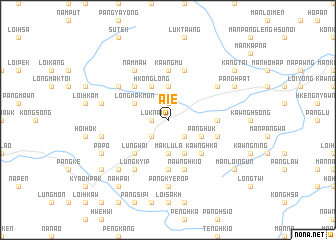
Aie (Shan, Myanmar)Aie is a town in the Shan region of Myanmar. An overview map of the region around Aie is displayed below.
regional and 3d topo map of Aie, Myanmar ::
Aie airports ::
The nearest airport is LSH - Lashio, located 45.7 km west of Aie.
Other airports nearby include KET - Kengtung (247.7 km south east), Nearby towns ::
Luknai (1.7km west) //
Nawngnoi (1.9km north) //
Ungkyawng (2.5km south west) //
Pānghung (2.5km south east) //
Maklu-la (3.7km south) //
Nampa-tep (3.7km north) //
Longmakmun (3.9km north west) //
Panghka (4.1km south east) //
Hkonglong (4.1km north west) //
Pānghuk (3.9km south east) //
Mān Mow (5.0km south west) //
Lungwai (5.0km south west) //
Nawnghkio (5.0km north west) //
Kawnghka (5.0km south east) //
Hpa-hsun (5.1km east) //
Kawngmu (5.6km north) //
Namhpat (5.6km south) //
Kawngmaklung (5.6km south) //
Nawnghsampu (5.4km east) //
Nawnghkam (5.8km north) //
Nawnghkio (5.8km south) //
Lungkyip (6.5km south west) //
Nammaw (6.5km north west) //
Namlenlong (6.3km north east) //
Mān Sawngmawng (6.3km north west) //
Pāngkyerop (7.4km south) //
Tintat (7.1km west) //
Kawnghka (7.1km west) //
Hkö-hkam (7.6km south west) //
[all distances 'as the bird flies' and approximate] 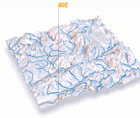 Places with similar names to Aie, Myanmar ::
Disclaimer :: Information on this page comes without warranty of any kind |
||
|
Where is Aie? Elevation and coordinates ::
Latitude (lat): 23°5'0"N Longitude (lon): 98°11'0"E
Elevation (approx.): 860m (map arrows pan, magnifying glasses zoom) |
||
|
Visiting Aie? Hotel/Accommodation ::
Book a hotel in Aie Travel Guide ::
Buy a travel guide for Myanmar rental cars ::
car rental offers GPS waypoint ::
download a GPX waypoint (PoI) of Aie for your GPS receiver
|
||