|
search place name
|
||
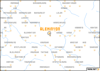
Ale Minyon (Rakhine, Myanmar)Ale Minyon is a town in the Rakhine region of Myanmar. An overview map of the region around Ale Minyon is displayed below.
regional and 3d topo map of Ale Minyon, Myanmar ::
Ale Minyon airports ::
The nearest airport is KYP - Kyaukpyu, located 77.8 km south west of Ale Minyon.
Other airports nearby include AKY - Sittwe (143.1 km west), SNW - Thandwe (145.1 km south), MDL - Mandalay Intl (284.3 km north east), Nearby towns ::
Minyon (0.0km north) //
Atet Minyon (1.9km north) //
Maung Bo Ywa (2.5km north east) //
Minyon (3.7km south) //
Dodan (3.5km east) //
Atet Dodan (3.5km east) //
Kaungwa (4.1km south west) //
Hnanchaung (5.1km north east) //
Auk Dodan (5.2km east) //
Auk Yebôk (5.2km west) //
Ponnabya (6.4km north west) //
Kethabet (6.6km south east) //
Atet Sundet (7.4km north) //
Ale Mahtein (7.0km west) //
Kinde (7.0km east) //
Thitswe (7.6km south) //
Padon (7.6km south) //
Paung (7.6km south west) //
Auk Sundet (8.2km north west) //
Lelon (8.2km north east) //
Paungwa (9.1km south west) //
Zawgyi (10.2km south east) //
[all distances 'as the bird flies' and approximate] 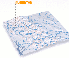 Places with similar names to Ale Minyon, Myanmar :: Disclaimer :: Information on this page comes without warranty of any kind |
||
|
Where is Ale Minyon? Elevation and coordinates ::
Latitude (lat): 19°46'0"N Longitude (lon): 94°11'0"E
Elevation (approx.): 188m (map arrows pan, magnifying glasses zoom) |
||
|
Visiting Ale Minyon? Hotel/Accommodation ::
Book a hotel in Ale Minyon Travel Guide ::
Buy a travel guide for Myanmar rental cars ::
car rental offers GPS waypoint ::
download a GPX waypoint (PoI) of Ale Minyon for your GPS receiver
|
||