|
search place name
|
||
Bantha (Mandalay, Myanmar)Bantha is a town in the Mandalay region of Myanmar. An overview map of the region around Bantha is displayed below.
regional and 3d topo map of Bantha, Myanmar ::

Bantha airports ::
The nearest airport is MDL - Mandalay Intl, located 69.2 km west of Bantha.
Other airports nearby include HEH - Heho (132.9 km south), LSH - Lashio (165.7 km north east), Nearby towns ::
Thayetchaung (1.7km west) //
Nalin (2.5km north west) //
Holein (2.5km north west) //
Chaungcha (2.5km north west) //
Pakin (2.5km north west) //
Kyandaw (3.7km south) //
Kyaingtaung (4.1km north west) //
Pawpyin (5.5km west) //
Myindaung (6.5km north west) //
Thinkadon (6.5km north west) //
Pyingyi (7.1km east) //
Inya (7.6km north west) //
Thike-taw (7.6km south west) //
Ywama (8.2km north west) //
Baw (7.8km south west) //
Pongon (7.8km south west) //
[all distances 'as the bird flies' and approximate] 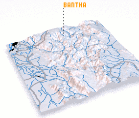 Places with similar names to Bantha, Myanmar ::
// Benthe (DE)
// Ban Ai Thui (TH)
// Ban A Thi (TH)
// Ban Na Tha (TH)
// Ban Na Tho (TH)
// Ban Ni The (TH)
// Ban Nua Tha (TH)
// Ban Tha (TH)
// Ban Tha (TH)
// Ban Tha (TH)
Disclaimer :: Information on this page comes without warranty of any kind |
||
|
Where is Bantha? Elevation and coordinates ::
Latitude (lat): 21°56'0"N Longitude (lon): 96°36'0"E
Elevation (approx.): 824m (map arrows pan, magnifying glasses zoom) |
||
|
Visiting Bantha? Hotel/Accommodation ::
Book a hotel in Bantha Travel Guide ::
Buy a travel guide for Myanmar rental cars ::
car rental offers GPS waypoint ::
download a GPX waypoint (PoI) of Bantha for your GPS receiver
|
||