|
search place name
|
||
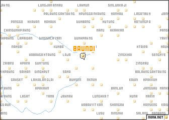
Baunoi (Kachin State, Myanmar)Baunoi is a town in the Kachin State region of Myanmar. An overview map of the region around Baunoi is displayed below.
regional and 3d topo map of Baunoi, Myanmar ::
nearby GPS traces from timatio ::
Baunoi airports ::
The nearest airport is MYT - Myitkyina, located 133.6 km north of Baunoi.
Other airports nearby include LSH - Lashio (136.3 km south), Nearby towns ::
Bumwa (1.9km north) //
Mong Wai (2.5km south west) //
Māru Wahtang (2.5km south east) //
Kādaw (2.5km north east) //
Hpau Lang (2.5km north east) //
Lāja (3.4km west) //
Dumhpawng (3.7km north) //
Sama (5.0km south west) //
Bumsen (5.8km south) //
Kumba (5.4km west) //
Nknum (5.8km south) //
Bumchyang (6.3km south west) //
Maru (6.5km north east) //
Mai Kung (6.5km south east) //
Panghok (6.8km east) //
Dumbang (7.4km north) //
Sinlum (7.6km north) //
Pangmo (7.6km north) //
Dingsa Chyāri (7.7km north west) //
Hutung (9.0km north east) //
Hkahkan (8.8km north east) //
Banlun (10.0km south east) //
Namje (10.0km south east) //
Momauk (10.0km north west) //
[all distances 'as the bird flies' and approximate] 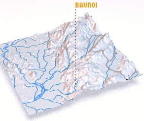 Places with similar names to Baunoi, Myanmar ::
Disclaimer :: Information on this page comes without warranty of any kind |
||
|
Where is Baunoi? Elevation and coordinates ::
Latitude (lat): 24°11'0"N Longitude (lon): 97°29'0"E
Elevation (approx.): 1005m (map arrows pan, magnifying glasses zoom) |
||
|
Visiting Baunoi? Hotel/Accommodation ::
Book a hotel in Baunoi Travel Guide ::
Buy a travel guide for Myanmar rental cars ::
car rental offers GPS waypoint ::
download a GPX waypoint (PoI) of Baunoi for your GPS receiver
|
||