|
search place name
|
||
Chaunggyi-wa (Myanmar)Chaunggyi-wa is a town in Myanmar. An overview map of the region around Chaunggyi-wa is displayed below.
regional and 3d topo map of Chaunggyi-wa, Myanmar ::

Chaunggyi-wa airports ::
The nearest airport is MGZ - Myeik, located 82.5 km north of Chaunggyi-wa.
Other airports nearby include HHQ - Prachuap Khiri Khan Hua Hin (169.7 km north east), Nearby towns ::
Tawbya (4.1km north west) //
Okpo-maw (4.1km south west) //
Kanzauk (5.2km south east) //
Lundaung (5.8km east) //
Gyon-gyon-gya (6.6km north west) //
Shwegēnyo (7.5km east) //
Kyaukpeik (7.6km north) //
Awēbindat (8.2km south east) //
Naungmyatngē (8.2km south east) //
Midogan (8.2km north east) //
Galet-to (8.3km south east) //
Okpogyauk (9.1km north west) //
[all distances 'as the bird flies' and approximate] 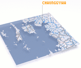 Places with similar names to Chaunggyi-wa, Myanmar ::
// Chaunggyiywa (MM)
// Chaunggyoywa (MM)
Disclaimer :: Information on this page comes without warranty of any kind |
||
|
Where is Chaunggyi-wa? Elevation and coordinates ::
Latitude (lat): 11°42'0"N Longitude (lon): 98°43'0"E
Elevation (approx.): -32768m (map arrows pan, magnifying glasses zoom) |
||
|
Visiting Chaunggyi-wa? Hotel/Accommodation ::
Book a hotel in Chaunggyi-wa Travel Guide ::
Buy a travel guide for Myanmar rental cars ::
car rental offers GPS waypoint ::
download a GPX waypoint (PoI) of Chaunggyi-wa for your GPS receiver
|
||