|
search place name
|
||
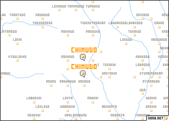
Chimudo (Kayin, Myanmar)Chimudo is a town in the Kayin region of Myanmar. An overview map of the region around Chimudo is displayed below.
regional and 3d topo map of Chimudo, Myanmar ::
Chimudo airports ::
The nearest airport is RGN - Yangon Intl, located 174.7 km south west of Chimudo.
Nearby towns ::
Kanelawdo (1.8km east) //
Kanedo (2.6km south east) //
Pokhido (3.5km west) //
Chimudo (3.7km south) //
Prilawdo (4.0km north east) //
Thikahedo (4.0km south west) //
Sawpawdo (5.1km south east) //
Wakado (5.6km south) //
Tekokhi (5.6km east) //
Pawsuko (5.8km north) //
Pawwahdo (6.6km south west) //
Pokhido (6.6km north west) //
Wakyokhi (6.5km south east) //
Tidemuta Sakan (7.6km north) //
Mawpu (9.0km south west) //
Lawwakodo (10.2km north east) //
[all distances 'as the bird flies' and approximate] 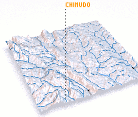 Places with similar names to Chimudo, Myanmar ::
Disclaimer :: Information on this page comes without warranty of any kind |
||
|
Where is Chimudo? Elevation and coordinates ::
Latitude (lat): 18°4'0"N Longitude (lon): 97°15'0"E
Elevation (approx.): 204m (map arrows pan, magnifying glasses zoom) |
||
|
Visiting Chimudo? Hotel/Accommodation ::
Book a hotel in Chimudo Travel Guide ::
Buy a travel guide for Myanmar rental cars ::
car rental offers GPS waypoint ::
download a GPX waypoint (PoI) of Chimudo for your GPS receiver
|
||