|
search place name
|
||
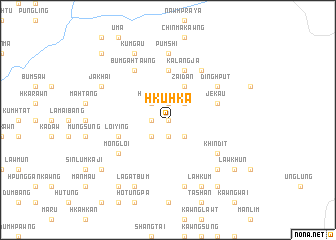
Hkuhka (Kachin State, Myanmar)Hkuhka is a town in the Kachin State region of Myanmar. An overview map of the region around Hkuhka is displayed below.
regional and 3d topo map of Hkuhka, Myanmar ::
Hkuhka airports ::
The nearest airport is MYT - Myitkyina, located 119.8 km north of Hkuhka.
Other airports nearby include LSH - Lashio (150.6 km south), Nearby towns ::
Loilung (0.0km north) //
Manmaw Kawng (1.9km south) //
Shadan Kawng (1.7km west) //
Munghka (1.7km west) //
Palawng Kawng (1.9km north) //
Yinsung (2.5km south west) //
Hkaibang (2.5km south east) //
Hpulum (2.5km north west) //
Hpridi (2.5km north east) //
Zaidan (4.1km north east) //
Maikyu (5.6km north) //
Loiying (5.4km west) //
Jekau (5.4km east) //
Kalangja (5.8km north) //
Mongloi (6.3km south west) //
Khindit (6.3km south east) //
Bum-gahtawng (6.5km north west) //
Ashang (6.5km north east) //
Dinghput (6.3km north east) //
Pumshi (7.4km north) //
Janmai (7.6km south) //
Bumtawn (7.5km south east) //
Lagatbum (8.1km south west) //
Kumbabum (8.1km south east) //
Lāhkum (8.1km south east) //
Jakhai (7.7km north west) //
Kumgau (8.1km north west) //
Gumtung (9.0km south east) //
Walai Hpungyang (9.0km south west) //
[all distances 'as the bird flies' and approximate] 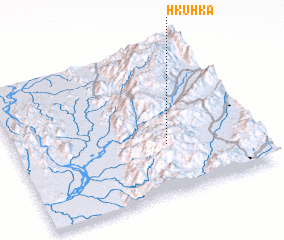 Places with similar names to Hkuhka, Myanmar ::
Disclaimer :: Information on this page comes without warranty of any kind |
||
|
Where is Hkuhka? Elevation and coordinates ::
Latitude (lat): 24°20'0"N Longitude (lon): 97°38'0"E
Elevation (approx.): 1392m (map arrows pan, magnifying glasses zoom) |
||
|
Visiting Hkuhka? Hotel/Accommodation ::
Book a hotel in Hkuhka Travel Guide ::
Buy a travel guide for Myanmar rental cars ::
car rental offers GPS waypoint ::
download a GPX waypoint (PoI) of Hkuhka for your GPS receiver
|
||