|
search place name
|
||
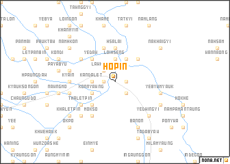
Hopin (Shan, Myanmar)Hopin is a town in the Shan region of Myanmar. An overview map of the region around Hopin is displayed below.
regional and 3d topo map of Hopin, Myanmar ::
Hopin airports ::
The nearest airport is HEH - Heho, located 54.7 km south of Hopin.
Other airports nearby include MDL - Mandalay Intl (107.2 km north west), LSH - Lashio (213.0 km north east), Nearby towns ::
Loi-kaw (1.7km west) //
Mwedaw (1.7km east) //
Kandaw (2.5km south east) //
Lawksawk (2.5km north west) //
Kandalet (3.5km west) //
Loi-hseng (3.7km north) //
Kon-nyawng (3.9km south west) //
Hweywa (4.1km north east) //
Papan (5.1km south west) //
Yedaw (5.1km north west) //
Nakhaigale (5.1km north east) //
Hsalai (5.6km north) //
Nanhu (5.8km north) //
Thaletpin (6.4km south west) //
Mokso (6.5km south west) //
Badu Tat Myo (6.4km north west) //
Myenigon (6.9km west) //
Kya-in (6.9km west) //
Thabyegon (7.2km west) //
Myegyigon (7.2km west) //
Nawngbo (7.2km west) //
Yebyu Myauk (7.2km east) //
Yebyu (7.2km east) //
Shinthe (7.6km south west) //
Yedwingyi (7.6km south east) //
Banon (8.2km south east) //
Yebyu Taung (7.8km south east) //
Namhkon (8.9km north west) //
Khaletpin (8.9km south west) //
[all distances 'as the bird flies' and approximate]  Places with similar names to Hopin, Myanmar ::
Disclaimer :: Information on this page comes without warranty of any kind |
||
|
Where is Hopin? Elevation and coordinates ::
Latitude (lat): 21°14'0"N Longitude (lon): 96°53'0"E
Elevation (approx.): 936m (map arrows pan, magnifying glasses zoom) |
||
|
Visiting Hopin? Hotel/Accommodation ::
Book a hotel in Hopin Travel Guide ::
Buy a travel guide for Myanmar rental cars ::
car rental offers GPS waypoint ::
download a GPX waypoint (PoI) of Hopin for your GPS receiver
|
||