|
search place name
|
||
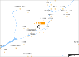
Hpākān (Kachin State, Myanmar)Hpākān is a town in the Kachin State region of Myanmar. An overview map of the region around Hpākān is displayed below.
regional and 3d topo map of Hpākān, Myanmar ::
Hpākān airports ::
The nearest airport is MYT - Myitkyina, located 107.2 km east of Hpākān.
Other airports nearby include PBU - Putao (219.7 km north east), MOH - Mohanbari Dibrugarh (244.1 km north west), Nearby towns ::
Hkānaw (1.9km south) //
Mamaung (1.7km west) //
Muwala (2.5km north west) //
Na-mahpi (2.5km south east) //
Malān (3.3km east) //
Māsāmaw (4.1km north east) //
Shulunghka (3.8km south west) //
Saingmaw (5.0km south west) //
Manna (5.0km west) //
Sabyi (5.0km west) //
Lonkin (6.2km north east) //
Nāmpāngon (6.2km south west) //
Mamon (6.2km south west) //
Lāmong (6.7km west) //
Tānggôn (7.5km north east) //
Sanhka (8.1km north east) //
Tawmaw (8.9km north west) //
Nammaw (10.0km south west) //
[all distances 'as the bird flies' and approximate] 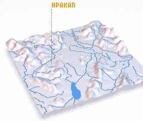 Places with similar names to Hpākān, Myanmar ::
Disclaimer :: Information on this page comes without warranty of any kind |
||
|
Where is Hpākān? Elevation and coordinates ::
Latitude (lat): 25°37'0"N Longitude (lon): 96°19'0"E
Elevation (approx.): 271m (map arrows pan, magnifying glasses zoom) |
||
|
Visiting Hpākān? Hotel/Accommodation ::
Book a hotel in Hpākān Travel Guide ::
Buy a travel guide for Myanmar rental cars ::
car rental offers GPS waypoint ::
download a GPX waypoint (PoI) of Hpākān for your GPS receiver
|
||