|
search place name
|
||
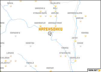
Hpre-hso-hku (Kayah, Myanmar)Hpre-hso-hku is a town in the Kayah region of Myanmar. An overview map of the region around Hpre-hso-hku is displayed below.
regional and 3d topo map of Hpre-hso-hku, Myanmar ::
Hpre-hso-hku airports ::
The nearest airport is HEH - Heho, located 193.9 km north of Hpre-hso-hku.
Nearby towns ::
Wān Hsuppawn (4.1km north east) //
Hwè-mawnun (5.1km north west) //
Ro-lè (7.4km north) //
Wān Lao (7.6km north) //
Bi-hku (7.6km north) //
Tawhku (7.7km south east) //
Kyaukhkaung (8.2km north west) //
Nawnoi (8.2km south east) //
Kè-ma-taw (7.9km south west) //
Htuchaung (9.1km south east) //
[all distances 'as the bird flies' and approximate] 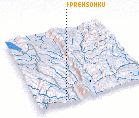 Places with similar names to Hpre-hso-hku, Myanmar ::
// Praia Sêca (BR)
// Prè-sawhku (MM)
// Prè-sawhku (MM)
// Parsch (AT)
// Prossegg (AT)
// Persico (US)
// Paarsch (DE)
// Preske (DE)
// Presseck (DE)
// Pressig (DE)
Disclaimer :: Information on this page comes without warranty of any kind |
||
|
Where is Hpre-hso-hku? Elevation and coordinates ::
Latitude (lat): 19°3'0"N Longitude (lon): 97°15'0"E
Elevation (approx.): 193m (map arrows pan, magnifying glasses zoom) |
||
|
Visiting Hpre-hso-hku? Hotel/Accommodation ::
Book a hotel in Hpre-hso-hku Travel Guide ::
Buy a travel guide for Myanmar rental cars ::
car rental offers GPS waypoint ::
download a GPX waypoint (PoI) of Hpre-hso-hku for your GPS receiver
|
||