|
search place name
|
||
Huangshuwo (Shan, Myanmar)Huangshuwo is a town in the Shan region of Myanmar. An overview map of the region around Huangshuwo is displayed below.
regional and 3d topo map of Huangshuwo, Myanmar ::

Huangshuwo airports ::
The nearest airport is LSH - Lashio, located 159.3 km south west of Huangshuwo.
Other airports nearby include MYT - Myitkyina (201.9 km north west), Nearby towns ::
Ka-wantzu (1.7km west) //
Chukôyin (1.9km north) //
Tapintzu (2.5km north east) //
Akuai Chai (2.5km north west) //
Mān Maw (3.4km west) //
Huoshangchiao (3.7km north) //
Lunghtang (3.9km south west) //
Ma-nganshan (3.9km north west) //
Sheokaunshan (4.1km south west) //
Chungshan (4.1km north east) //
Tapatzushui (4.1km north east) //
Ma-sai-ai (5.0km south west) //
Meihualing (5.0km north east) //
Tsungkan (5.4km west) //
Ta Chaitzu (5.4km east) //
Lantuishan (6.3km south east) //
Laohang Chai (6.3km south west) //
Shaotishan (6.5km south east) //
Motai (6.3km north east) //
Saopa Chai (6.8km west) //
Pachia Chai (6.8km west) //
Yanglo-tzu Chai (7.0km east) //
Chiungkou (7.0km east) //
Chatzushu (7.5km south west) //
Tassushu (7.7km north east) //
Laolongko (8.8km south west) //
[all distances 'as the bird flies' and approximate] 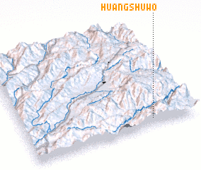 Places with similar names to Huangshuwo, Myanmar :: Disclaimer :: Information on this page comes without warranty of any kind |
||
|
Where is Huangshuwo? Elevation and coordinates ::
Latitude (lat): 24°5'0"N Longitude (lon): 98°45'0"E
Elevation (approx.): 2169m (map arrows pan, magnifying glasses zoom) |
||
|
Visiting Huangshuwo? Hotel/Accommodation ::
Book a hotel in Huangshuwo Travel Guide ::
Buy a travel guide for Myanmar rental cars ::
car rental offers GPS waypoint ::
download a GPX waypoint (PoI) of Huangshuwo for your GPS receiver
|
||