|
search place name
|
||
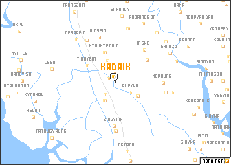
Kadaik (Mon State, Myanmar)Kadaik is a town in the Mon State region of Myanmar. An overview map of the region around Kadaik is displayed below.
regional and 3d topo map of Kadaik, Myanmar ::
Kadaik airports ::
The nearest airport is RGN - Yangon Intl, located 138.7 km west of Kadaik.
Nearby towns ::
Inbyaung (1.3km north west) //
Tagundaing (1.6km north) //
Katun (2.5km south west) //
Ale-ywa (3.0km south east) //
Pan-gon (3.3km south west) //
Pauktaw (3.7km north) //
Chaungbya (4.1km south east) //
Kyaukyedwin (5.1km north) //
Yinnyein (5.1km north west) //
Ananbin (6.1km north east) //
Zingyaik (7.0km south) //
Ingwe (7.0km north east) //
Mepaung (7.4km east) //
Winsein (7.7km north) //
Palat (7.8km south) //
Aungsaing (8.2km north west) //
Thitkaung (8.0km east) //
Nyaunggyaung (9.0km north) //
Debarein (9.2km north west) //
Shanzu (9.8km north east) //
Wagoktaw (10.4km north east) //
Kyettuywethaung (10.3km north east) //
[all distances 'as the bird flies' and approximate] 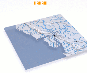 Places with similar names to Kadaik, Myanmar ::
Disclaimer :: Information on this page comes without warranty of any kind |
||
|
Where is Kadaik? Elevation and coordinates ::
Latitude (lat): 16°45'51"N Longitude (lon): 97°25'34"E
Elevation (approx.): 23m (map arrows pan, magnifying glasses zoom) |
||
|
Visiting Kadaik? Hotel/Accommodation ::
Book a hotel in Kadaik Travel Guide ::
Buy a travel guide for Myanmar rental cars ::
car rental offers GPS waypoint ::
download a GPX waypoint (PoI) of Kadaik for your GPS receiver
|
||