|
search place name
|
||
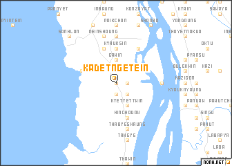
Kadetngetein (Myanmar)Kadetngetein is a town in Myanmar. An overview map of the region around Kadetngetein is displayed below.
regional and 3d topo map of Kadetngetein, Myanmar ::
Kadetngetein airports ::
The nearest airport is MGZ - Myeik, located 167.7 km south of Kadetngetein.
Other airports nearby include HHQ - Prachuap Khiri Khan Hua Hin (239.1 km south east), Nearby towns ::
Nyaunggon (0.0km north) //
Yathein (0.0km north) //
Myaukkabat (1.9km south) //
Wetthagin (1.8km east) //
Yebyu (1.9km north) //
Pyingyaung (2.6km south east) //
Peinnedaw (2.6km north west) //
Teingyi (3.7km north) //
Gaw-in (3.7km north) //
Meinmazaw (4.1km south east) //
Kyetyettwin (4.1km south east) //
Kadetngeseik (4.0km north east) //
Lethunkan (5.6km north) //
Kyauksin (5.6km north) //
Thalin (5.8km south) //
Hinchodaw (5.8km south) //
Zawgyun (5.8km south) //
Nyinmaw (5.8km north) //
Tizit (5.7km west) //
Kataungni (6.6km north east) //
Kanyonkyun (7.2km east) //
Sitpye (7.4km north) //
Thabyeshaung (7.6km south) //
Peinshaung (7.6km north) //
Sanhlan (10.3km north west) //
[all distances 'as the bird flies' and approximate] 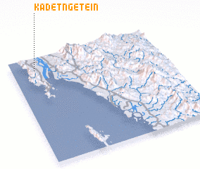 Places with similar names to Kadetngetein, Myanmar :: Disclaimer :: Information on this page comes without warranty of any kind |
||
|
Where is Kadetngetein? Elevation and coordinates ::
Latitude (lat): 13°53'0"N Longitude (lon): 98°9'0"E
Elevation (approx.): 6m (map arrows pan, magnifying glasses zoom) |
||
|
Visiting Kadetngetein? Hotel/Accommodation ::
Book a hotel in Kadetngetein Travel Guide ::
Buy a travel guide for Myanmar rental cars ::
car rental offers GPS waypoint ::
download a GPX waypoint (PoI) of Kadetngetein for your GPS receiver
|
||