|
search place name
|
||
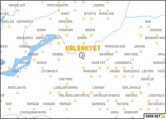
Kalehkyet (Kachin State, Myanmar)Kalehkyet is a town in the Kachin State region of Myanmar. An overview map of the region around Kalehkyet is displayed below.
regional and 3d topo map of Kalehkyet, Myanmar ::
Kalehkyet airports ::
The nearest airport is MYT - Myitkyina, located 114.9 km north of Kalehkyet.
Other airports nearby include LSH - Lashio (155.1 km south), Nearby towns ::
Lana (1.9km south) //
Shāre (3.7km north) //
Wang-gahtawng (3.9km south east) //
Kumhtat (3.9km south east) //
Mungdungkong (3.9km south east) //
Hpākawn (4.1km south east) //
N'hkrut (3.9km north west) //
Mān Dau (5.0km south east) //
Zaibru (5.1km west) //
Hkarawn (5.1km east) //
Nawku (5.6km north) //
Bumsaw (5.4km east) //
Mandau (5.4km east) //
Banma (5.8km north) //
Wamaw (5.4km east) //
Ugyi (6.3km north west) //
N'hkrut (6.3km north west) //
Tinghkam (6.5km north west) //
Bumbrai (6.5km south west) //
Numrawng (6.5km south west) //
Cheyang (6.5km south west) //
Lawdan (7.4km south) //
Pranghdung (7.0km east) //
Nawnghkoi (7.0km east) //
Kumpyi (7.6km south) //
Myohaung (7.5km north west) //
Myothit (7.5km north west) //
Hintha (7.7km north west) //
Tai-chaung (7.7km north west) //
[all distances 'as the bird flies' and approximate] 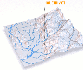 Places with similar names to Kalehkyet, Myanmar :: Disclaimer :: Information on this page comes without warranty of any kind |
||
|
Where is Kalehkyet? Elevation and coordinates ::
Latitude (lat): 24°21'0"N Longitude (lon): 97°27'0"E
Elevation (approx.): 391m (map arrows pan, magnifying glasses zoom) |
||
|
Visiting Kalehkyet? Hotel/Accommodation ::
Book a hotel in Kalehkyet Travel Guide ::
Buy a travel guide for Myanmar rental cars ::
car rental offers GPS waypoint ::
download a GPX waypoint (PoI) of Kalehkyet for your GPS receiver
|
||