|
search place name
|
||
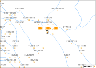
Kandawgon (Shan, Myanmar)Kandawgon is a town in the Shan region of Myanmar. An overview map of the region around Kandawgon is displayed below.
regional and 3d topo map of Kandawgon, Myanmar ::
Kandawgon airports ::
The nearest airport is MDL - Mandalay Intl, located 53.9 km north west of Kandawgon.
Other airports nearby include HEH - Heho (84.6 km south east), LSH - Lashio (222.1 km north east), Nearby towns ::
Daungmizon (1.7km east) //
Daungmi (3.7km north) //
Thapangyo (4.1km north east) //
Myo-gyi (5.1km north west) //
Padauk-aik (5.1km north west) //
Kyungyi (5.6km north) //
Tebingaing (5.8km south) //
Hseywa (6.5km north west) //
Myitson (7.1km east) //
Ye-htwetkyi (7.6km south west) //
Sakangyi (8.2km south west) //
Kyunpingaing (8.9km north west) //
Kinywa (8.9km north west) //
[all distances 'as the bird flies' and approximate] 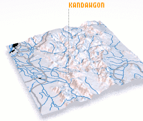 Places with similar names to Kandawgon, Myanmar ::
// Canaducan (PH)
// Candaigan (PH)
// Guindagan (PH)
// Guintiguian (PH)
// Guintocan (PH)
// Guano de Cana (CU)
// Gündoğan (TR)
// Gündoğan (TR)
// Gündoğan (TR)
// Gündoğan (TR)
Disclaimer :: Information on this page comes without warranty of any kind |
||
|
Where is Kandawgon? Elevation and coordinates ::
Latitude (lat): 21°25'0"N Longitude (lon): 96°24'0"E
Elevation (approx.): 265m (map arrows pan, magnifying glasses zoom) |
||
|
Visiting Kandawgon? Hotel/Accommodation ::
Book a hotel in Kandawgon Travel Guide ::
Buy a travel guide for Myanmar rental cars ::
car rental offers GPS waypoint ::
download a GPX waypoint (PoI) of Kandawgon for your GPS receiver
|
||