|
search place name
|
||
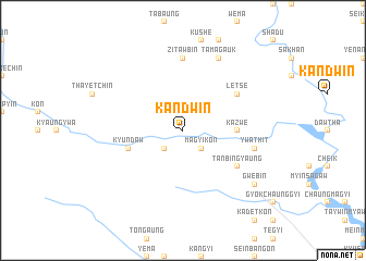
Kandwin (Myanmar)Kandwin is a town in Myanmar. An overview map of the region around Kandwin is displayed below.
regional and 3d topo map of Kandwin, Myanmar ::
Kandwin airports ::
The nearest airport is MDL - Mandalay Intl, located 157.9 km north east of Kandwin.
Other airports nearby include AKY - Sittwe (208.9 km south west), KYP - Kyaukpyu (211.7 km south west), Nearby towns ::
Nyaungbin-yedwin (2.5km south west) //
Magyikon (2.5km south east) //
Kazwe (5.2km east) //
Kyundaw (5.5km west) //
Tanbingyaung (6.4km south east) //
Letse (6.4km north east) //
Sinthahmwe (7.4km north) //
Zitawbin (7.4km north) //
Ywathit (7.2km east) //
Tamagauk (8.2km north east) //
Gwebin (8.9km south east) //
[all distances 'as the bird flies' and approximate]  Places with similar names to Kandwin, Myanmar ::
// Kānī Towān (IQ)
// Gandhwāni (IN)
// Kandwān (IN)
// Kendawinna (LK)
// Guanduwan (CN)
// Kandwin (MM)
// Kandwin (MM)
// Kandwin (MM)
Disclaimer :: Information on this page comes without warranty of any kind |
||
|
Where is Kandwin? Elevation and coordinates ::
Latitude (lat): 21°2'0"N Longitude (lon): 94°38'0"E
Elevation (approx.): 154m (map arrows pan, magnifying glasses zoom) |
||
|
Visiting Kandwin? Hotel/Accommodation ::
Book a hotel in Kandwin Travel Guide ::
Buy a travel guide for Myanmar rental cars ::
car rental offers GPS waypoint ::
download a GPX waypoint (PoI) of Kandwin for your GPS receiver
|
||