|
search place name
|
||
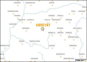
Kangyat (Shan, Myanmar)Kangyat is a town in the Shan region of Myanmar. An overview map of the region around Kangyat is displayed below.
regional and 3d topo map of Kangyat, Myanmar ::
Kangyat airports ::
The nearest airport is LSH - Lashio, located 145.8 km west of Kangyat.
Other airports nearby include KET - Kengtung (178.2 km south), Nearby towns ::
Laklai (4.1km north east) //
Mān Kalu (3.9km south east) //
Luhkala (6.3km north west) //
Mo-pang (6.5km north east) //
Yawngsam (6.3km north east) //
Yawnglawng (6.5km south west) //
Pa-nung (6.8km east) //
Kanamon (6.8km west) //
Yawngo (7.1km east) //
Lukkum (8.2km south east) //
Tapale (8.8km north east) //
[all distances 'as the bird flies' and approximate] 
Disclaimer :: Information on this page comes without warranty of any kind |
||
|
Where is Kangyat? Elevation and coordinates ::
Latitude (lat): 22°51'0"N Longitude (lon): 99°10'0"E
Elevation (approx.): 1383m (map arrows pan, magnifying glasses zoom) |
||
|
Visiting Kangyat? Hotel/Accommodation ::
Book a hotel in Kangyat Travel Guide ::
Buy a travel guide for Myanmar rental cars ::
car rental offers GPS waypoint ::
download a GPX waypoint (PoI) of Kangyat for your GPS receiver
|
||