|
search place name
|
||
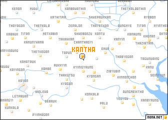
Kantha (Bago, Myanmar)Kantha is a town in the Bago region of Myanmar. An overview map of the region around Kantha is displayed below.
regional and 3d topo map of Kantha, Myanmar ::
Kantha airports ::
The nearest airport is RGN - Yangon Intl, located 59.0 km west of Kantha.
Nearby towns ::
Owa (2.3km north west) //
Kyinigyaung (2.5km south) //
Sakangyi (2.7km east) //
Chanthagyi (3.1km north) //
Aungtha (3.2km north east) //
Nyaungbintha (3.5km south east) //
Tapun (3.8km west) //
Shwebonzu (4.9km north) //
Kyongan (4.9km south east) //
Emun (4.8km east) //
Takawkan (5.4km north west) //
Aukkyin (5.5km west) //
Thakutsu (5.7km south west) //
Kantu (6.0km north east) //
Kanmyin (6.6km north east) //
Zepalon (7.1km north) //
Kyagan (7.2km south west) //
Zibyubin (7.2km south east) //
Thayetkon (7.6km north east) //
Konkala (8.7km south) //
Kanyin (8.4km north east) //
Kangon (8.7km south) //
Kambe (8.5km west) //
Metkabin (8.8km north west) //
Shwepaukkan (9.3km north) //
Kadatsein (9.7km north east) //
Kathitpin (10.2km north west) //
[all distances 'as the bird flies' and approximate] 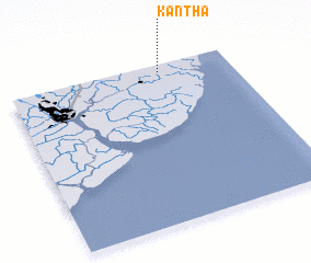 Places with similar names to Kantha, Myanmar ::
Disclaimer :: Information on this page comes without warranty of any kind |
||
|
Where is Kantha? Elevation and coordinates ::
Latitude (lat): 16°57'20"N Longitude (lon): 96°41'5"E
Elevation (approx.): 10m (map arrows pan, magnifying glasses zoom) |
||
|
Visiting Kantha? Hotel/Accommodation ::
Book a hotel in Kantha Travel Guide ::
Buy a travel guide for Myanmar rental cars ::
car rental offers GPS waypoint ::
download a GPX waypoint (PoI) of Kantha for your GPS receiver
|
||