|
search place name
|
||
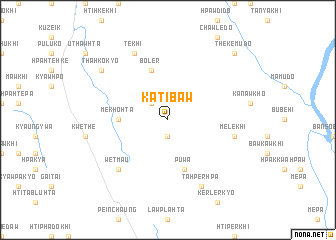
Katibaw (Kayin, Myanmar)Katibaw is a town in the Kayin region of Myanmar. An overview map of the region around Katibaw is displayed below.
regional and 3d topo map of Katibaw, Myanmar ::
Katibaw airports ::
The nearest airport is RGN - Yangon Intl, located 181.7 km south west of Katibaw.
Other airports nearby include LPT - Lampang (213.8 km east), Nearby towns ::
Mekhokhi (1.9km south) //
Bleper (2.6km north west) //
Mekhohta (5.3km west) //
Boler (5.8km north) //
Puwa (5.8km south) //
Melekhi (7.3km east) //
Wetma-u (7.7km south west) //
Tekhi (8.2km north west) //
Tahperhpa (8.2km south east) //
Menyuhta (9.0km north west) //
Thahkokyo (9.0km north west) //
Thekemudo (10.2km north east) //
[all distances 'as the bird flies' and approximate]  Places with similar names to Katibaw, Myanmar ::
Disclaimer :: Information on this page comes without warranty of any kind |
||
|
Where is Katibaw? Elevation and coordinates ::
Latitude (lat): 17°51'0"N Longitude (lon): 97°32'0"E
Elevation (approx.): 303m (map arrows pan, magnifying glasses zoom) |
||
|
Visiting Katibaw? Hotel/Accommodation ::
Book a hotel in Katibaw Travel Guide ::
Buy a travel guide for Myanmar rental cars ::
car rental offers GPS waypoint ::
download a GPX waypoint (PoI) of Katibaw for your GPS receiver
|
||