|
search place name
|
||
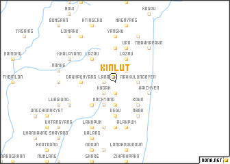
Kinlut (Kachin State, Myanmar)Kinlut is a town in the Kachin State region of Myanmar. An overview map of the region around Kinlut is displayed below.
regional and 3d topo map of Kinlut, Myanmar ::
Kinlut airports ::
The nearest airport is MYT - Myitkyina, located 86.6 km north of Kinlut.
Other airports nearby include LSH - Lashio (183.1 km south), Nearby towns ::
Dingka (1.9km north) //
Dinggram (1.9km south) //
Lana (1.7km west) //
Ningpawn (1.7km west) //
Möng Lai (2.5km north east) //
Kugam (2.5km south west) //
Kalo Kong (2.5km south west) //
Nawku Lungbyen (3.4km east) //
Sataw (3.7km south) //
Chetang (3.7km south) //
Lazau (4.1km north east) //
Machyang (4.1km south west) //
Hkatawng (4.1km south west) //
Kawn (5.0km south east) //
Lāzau (5.0km north west) //
Kasu Kawng (5.0km south west) //
Dawhpumyang (5.1km west) //
Mangnyan (5.6km north) //
Wedu (5.6km south) //
Ura (5.8km north) //
Waichyen (5.4km east) //
N'baw (6.5km south east) //
Yangwu (7.4km north) //
Maraw Dawng (7.4km south) //
Alawpum (7.6km south) //
Yikhu (7.6km south) //
Sumpra (7.6km south) //
N'baw Marawn (7.5km north east) //
Wajau-dingsa (8.1km north east) //
[all distances 'as the bird flies' and approximate] 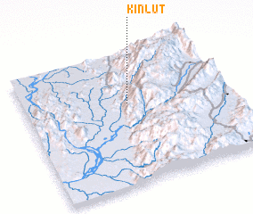 Places with similar names to Kinlut, Myanmar ::
// Canluto (PH)
// Kanalate (PH)
// Cana Alta (CU)
// Canalete (CU)
// Canalito (CU)
// Guano Alto (CU)
// Günaltı (TR)
// Kinlet (GB)
// Quiuña Alto (CL)
// Canalete (CO)
Disclaimer :: Information on this page comes without warranty of any kind |
||
|
Where is Kinlut? Elevation and coordinates ::
Latitude (lat): 24°37'0"N Longitude (lon): 97°31'0"E
Elevation (approx.): 856m (map arrows pan, magnifying glasses zoom) |
||
|
Visiting Kinlut? Hotel/Accommodation ::
Book a hotel in Kinlut Travel Guide ::
Buy a travel guide for Myanmar rental cars ::
car rental offers GPS waypoint ::
download a GPX waypoint (PoI) of Kinlut for your GPS receiver
|
||