|
search place name
|
||
Konywa (Mandalay, Myanmar)Konywa is a town in the Mandalay region of Myanmar. An overview map of the region around Konywa is displayed below.
regional and 3d topo map of Konywa, Myanmar ::

Konywa airports ::
The nearest airport is MDL - Mandalay Intl, located 66.1 km north of Konywa.
Other airports nearby include HEH - Heho (82.8 km south east), LSH - Lashio (267.5 km north east), Nearby towns ::
Dongon (0.0km north) //
Mingon (0.0km north) //
Nyaungokpi (0.0km north) //
Kyaunggon (1.7km west) //
Yoywa (2.5km south west) //
Magyidaw (2.5km south west) //
Kyaukpongon (3.7km south) //
Ywethi (3.7km south) //
Suban (4.1km north east) //
Yozon (3.9km south east) //
Khingyi (5.1km north west) //
Nyaungbintha (5.2km west) //
Magyi-ok (5.2km east) //
Kyaunggon (5.5km west) //
Myingyakan (6.5km north east) //
Kanzwe (6.5km north east) //
Htandaw (6.4km south east) //
Mingon (7.4km south) //
Thinganzwe (7.6km north) //
Myedaingkan (7.2km west) //
Seywa (7.6km south) //
Beingwe (7.2km west) //
Yezon (7.2km west) //
Kyauk-o (7.6km south) //
Songon (7.6km south) //
Tamagan (7.6km south) //
Kokkobin (7.6km south) //
Kantha (8.2km north west) //
Wundwin (7.8km south west) //
[all distances 'as the bird flies' and approximate] 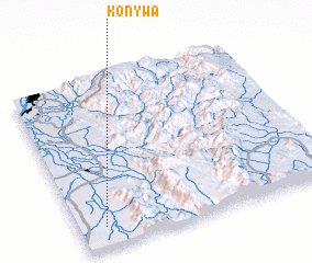 Places with similar names to Konywa, Myanmar ::
Disclaimer :: Information on this page comes without warranty of any kind |
||
|
Where is Konywa? Elevation and coordinates ::
Latitude (lat): 21°7'0"N Longitude (lon): 96°6'0"E
Elevation (approx.): 125m (map arrows pan, magnifying glasses zoom) |
||
|
Visiting Konywa? Hotel/Accommodation ::
Book a hotel in Konywa Travel Guide ::
Buy a travel guide for Myanmar rental cars ::
car rental offers GPS waypoint ::
download a GPX waypoint (PoI) of Konywa for your GPS receiver
|
||