|
search place name
|
||
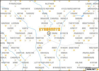
Kyabannyo (Sagaing, Myanmar)Kyabannyo is a town in the Sagaing region of Myanmar. An overview map of the region around Kyabannyo is displayed below.
regional and 3d topo map of Kyabannyo, Myanmar ::
Kyabannyo airports ::
The nearest airport is MDL - Mandalay Intl, located 132.2 km south east of Kyabannyo.
Other airports nearby include IMF - Imphal (269.2 km north west), Nearby towns ::
Ye-u (1.9km south) //
Thayetpinzu (1.9km south) //
Nwabaung (1.7km west) //
Yadaw (1.7km east) //
Thanthe (3.9km south west) //
Ywathit (3.9km north west) //
Pein-ga (4.1km north west) //
Myindaung (3.9km south east) //
Tandaw (5.0km south west) //
Leywa (5.0km north east) //
Myingya (5.1km east) //
Bodegon (5.8km north) //
Satthe (5.8km north) //
Inbat (5.8km south) //
Chaung-u (5.8km north) //
Moksi (6.5km south west) //
Thawatti (6.3km north east) //
Maya-in (6.5km south east) //
Zawa (6.8km west) //
Kokkozu (7.6km south) //
Tada-u (7.1km west) //
Hnawgon (7.1km west) //
Indaw (7.6km north) //
Myagan (7.6km south east) //
Monhla (7.6km north east) //
Mondaw (8.2km south east) //
Zigan (8.2km north east) //
Inbauk (9.0km south east) //
Pinzeingin (9.0km north east) //
[all distances 'as the bird flies' and approximate]  Places with similar names to Kyabannyo, Myanmar :: Disclaimer :: Information on this page comes without warranty of any kind |
||
|
Where is Kyabannyo? Elevation and coordinates ::
Latitude (lat): 22°47'0"N Longitude (lon): 95°26'0"E
Elevation (approx.): 104m (map arrows pan, magnifying glasses zoom) |
||
|
Visiting Kyabannyo? Hotel/Accommodation ::
Book a hotel in Kyabannyo Travel Guide ::
Buy a travel guide for Myanmar rental cars ::
car rental offers GPS waypoint ::
download a GPX waypoint (PoI) of Kyabannyo for your GPS receiver
|
||