|
search place name
|
||
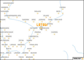
Latadi (Kachin State, Myanmar)Latadi is a town in the Kachin State region of Myanmar. An overview map of the region around Latadi is displayed below.
regional and 3d topo map of Latadi, Myanmar ::
Latadi airports ::
The nearest airport is PBU - Putao, located 114.8 km west of Latadi.
Other airports nearby include MYT - Myitkyina (242.2 km south west), Nearby towns ::
Bazung (1.6km east) //
Pawadu (2.5km south west) //
Jigawng (3.7km north) //
Chituhpa (3.3km west) //
Kyandi (3.8km north east) //
Nasē (5.0km north west) //
Timme (5.0km north east) //
Lower Bazul (5.0km south west) //
Takwade (4.9km west) //
Chirang (5.3km east) //
Miche (5.8km north) //
Rejing (5.8km north) //
Maring (6.5km north east) //
Lagalaw (6.2km south west) //
Namjing (7.6km north) //
Dawadi (7.4km south west) //
Zala (7.4km south west) //
Yungnam (7.6km north west) //
Sapchika (7.6km north east) //
Tashilong (8.1km south west) //
Nyitadi (9.9km north east) //
Bāza (9.9km north east) //
[all distances 'as the bird flies' and approximate] 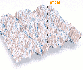 Places with similar names to Latadi, Myanmar ::
Disclaimer :: Information on this page comes without warranty of any kind |
||
|
Where is Latadi? Elevation and coordinates ::
Latitude (lat): 27°16'0"N Longitude (lon): 98°35'0"E
Elevation (approx.): 1982m (map arrows pan, magnifying glasses zoom) |
||
|
Visiting Latadi? Hotel/Accommodation ::
Book a hotel in Latadi Travel Guide ::
Buy a travel guide for Myanmar rental cars ::
car rental offers GPS waypoint ::
download a GPX waypoint (PoI) of Latadi for your GPS receiver
|
||