|
search place name
|
||
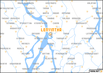
Lenyintha (Rakhine, Myanmar)Lenyintha is a town in the Rakhine region of Myanmar. An overview map of the region around Lenyintha is displayed below.
regional and 3d topo map of Lenyintha, Myanmar ::
Lenyintha airports ::
The nearest airport is AKY - Sittwe, located 50.3 km south west of Lenyintha.
Other airports nearby include KYP - Kyaukpyu (130.7 km south), CXB - Cox's Bazar Coxs Bazar (155.9 km north west), CGP - Chittagong Shah Amanat Intl (232.2 km north west), Nearby towns ::
Kadawa (1.9km north) //
Tandin (2.5km north east) //
Pyadai (3.7km south) //
Nyaunggyon (3.9km south west) //
Thandaya (3.9km south east) //
Chera (4.1km north east) //
Kyeingyaung (5.1km north west) //
Nayigan (5.2km west) //
Tawbwe (5.6km north) //
Thama (5.2km east) //
Dabe (6.6km south west) //
Minzegyaung (6.6km north west) //
Sattha (7.6km south) //
Banyo (7.6km north) //
Nagan (7.6km north) //
Dawgwe (7.6km south east) //
Kalaga (7.6km north east) //
Pyaungbya (8.2km south east) //
Pazunbe (9.1km north east) //
Thedet (10.2km north west) //
[all distances 'as the bird flies' and approximate] 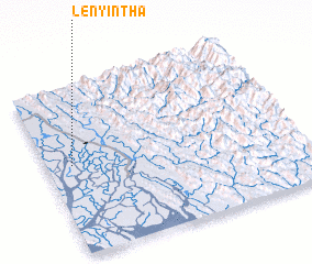 Places with similar names to Lenyintha, Myanmar :: Disclaimer :: Information on this page comes without warranty of any kind |
||
|
Where is Lenyintha? Elevation and coordinates ::
Latitude (lat): 20°32'0"N Longitude (lon): 93°6'0"E
Elevation (approx.): 2m (map arrows pan, magnifying glasses zoom) |
||
|
Visiting Lenyintha? Hotel/Accommodation ::
Book a hotel in Lenyintha Travel Guide ::
Buy a travel guide for Myanmar rental cars ::
car rental offers GPS waypoint ::
download a GPX waypoint (PoI) of Lenyintha for your GPS receiver
|
||