|
search place name
|
||
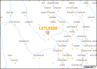
Letlegon (Shan, Myanmar)Letlegon is a town in the Shan region of Myanmar. An overview map of the region around Letlegon is displayed below.
regional and 3d topo map of Letlegon, Myanmar ::
Letlegon airports ::
The nearest airport is HEH - Heho, located 23.8 km east of Letlegon.
Other airports nearby include MDL - Mandalay Intl (118.7 km north west), Nearby towns ::
Pwelashwegon (1.9km south) //
Taunggyun (1.7km west) //
Mwedaw (2.5km north east) //
Kywedat (2.5km north west) //
Yebok (4.1km north east) //
Ywama (5.1km south east) //
Myetkha-in (5.1km north west) //
Ngapyawdaw (5.8km south) //
Konbaw (5.8km north) //
Paungdaw (5.5km east) //
Thinbawbin (6.6km south east) //
Kywethegon (6.4km south east) //
Peyindaung (6.6km north east) //
Myinmu (6.4km north east) //
Hngetpyawdaw (7.4km north) //
Myegya (7.2km east) //
Namhkom (7.6km north) //
Le-eingon (7.6km south east) //
Kyaungna (8.2km south east) //
Legaung (7.9km north west) //
Ywathitkon (9.1km south east) //
Nyaungzanbu (10.1km south east) //
[all distances 'as the bird flies' and approximate] 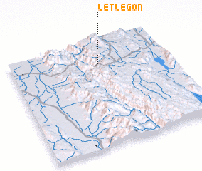 Places with similar names to Letlegon, Myanmar ::
// Lotlakani (BW)
// Lude Luekon (NG)
Disclaimer :: Information on this page comes without warranty of any kind |
||
|
Where is Letlegon? Elevation and coordinates ::
Latitude (lat): 20°47'0"N Longitude (lon): 96°34'0"E
Elevation (approx.): 1360m (map arrows pan, magnifying glasses zoom) |
||
|
Visiting Letlegon? Hotel/Accommodation ::
Book a hotel in Letlegon Travel Guide ::
Buy a travel guide for Myanmar rental cars ::
car rental offers GPS waypoint ::
download a GPX waypoint (PoI) of Letlegon for your GPS receiver
|
||