|
search place name
|
||
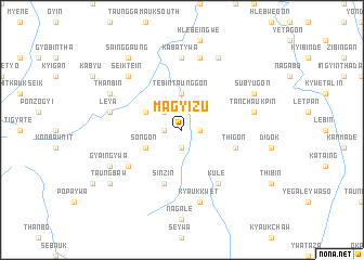
Magyizu (Mandalay, Myanmar)Magyizu is a town in the Mandalay region of Myanmar. An overview map of the region around Magyizu is displayed below.
regional and 3d topo map of Magyizu, Myanmar ::
Magyizu airports ::
The nearest airport is MDL - Mandalay Intl, located 104.8 km north east of Magyizu.
Other airports nearby include HEH - Heho (157.8 km east), KYP - Kyaukpyu (253.7 km south west), Nearby towns ::
Hlaingtha (1.9km south) //
Thangyigon (1.7km east) //
Kangon (1.7km west) //
Kya-ne-aing (2.5km north west) //
Tebintaunggon (3.7km north) //
Legyi (3.9km north west) //
Songon (3.9km south west) //
Thigon (5.5km east) //
Sinzin (5.8km south) //
Myauktaw (6.4km south west) //
Kule (6.5km south east) //
Kabatywa (7.4km north) //
Myingyangon (7.2km east) //
Leya (7.2km west) //
Tabaukkon (7.2km west) //
Tanchaukpin (7.2km east) //
Gwedaukkon (7.2km west) //
Ywatha (7.6km north) //
Kyaukkwet (7.6km south) //
Seiktein (7.6km north west) //
Gyaingywa (7.9km south west) //
Thanbin (7.9km north west) //
Subyugon (7.9km north east) //
Myinthadaung (8.2km north east) //
Sainggaung (9.0km north west) //
Taungbaw (8.9km south west) //
[all distances 'as the bird flies' and approximate]  Places with similar names to Magyizu, Myanmar ::
Disclaimer :: Information on this page comes without warranty of any kind |
||
|
Where is Magyizu? Elevation and coordinates ::
Latitude (lat): 21°0'0"N Longitude (lon): 95°18'0"E
Elevation (approx.): 354m (map arrows pan, magnifying glasses zoom) |
||
|
Visiting Magyizu? Hotel/Accommodation ::
Book a hotel in Magyizu Travel Guide ::
Buy a travel guide for Myanmar rental cars ::
car rental offers GPS waypoint ::
download a GPX waypoint (PoI) of Magyizu for your GPS receiver
|
||