|
search place name
|
||
Mān Kang (Shan, Myanmar)Mān Kang is a town in the Shan region of Myanmar. An overview map of the region around Mān Kang is displayed below.
regional and 3d topo map of Mān Kang, Myanmar ::

Mān Kang airports ::
The nearest airport is KET - Kengtung, located 126.7 km south east of Mān Kang.
Other airports nearby include LSH - Lashio (147.2 km north west), MOG - Mong Hsat (194.5 km south), THL - Tachilek Tachileik (220.6 km south east), Nearby towns ::
Mān Namkung (1.9km north) //
Mān Hta-lwa (1.7km east) //
Mān To-la (2.5km north west) //
Mān Pangkawk (5.6km south) //
Weng Kao (5.8km north) //
Ta-kut (6.3km south west) //
Mān Paklōng (6.5km north east) //
Mān Hsūmhpü (7.1km east) //
Mān Lakhka (7.1km west) //
Mān Makhkam (9.0km south west) //
Mān Hwe-wai (9.0km north west) //
Wān Motle (9.0km south east) //
Mān Hkamtan (8.8km south west) //
Mān Nawkla (10.1km north east) //
Wān Pangmawng (10.1km south east) //
Mān Mēn (10.1km south west) //
[all distances 'as the bird flies' and approximate] 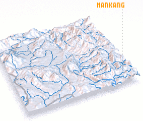 Places with similar names to Mān Kang, Myanmar ::
Disclaimer :: Information on this page comes without warranty of any kind |
||
|
Where is Mān Kang? Elevation and coordinates ::
Latitude (lat): 22°15'0"N Longitude (lon): 98°57'0"E
Elevation (approx.): 1020m (map arrows pan, magnifying glasses zoom) |
||
|
Visiting Mān Kang? Hotel/Accommodation ::
Book a hotel in Mān Kang Travel Guide ::
Buy a travel guide for Myanmar rental cars ::
car rental offers GPS waypoint ::
download a GPX waypoint (PoI) of Mān Kang for your GPS receiver
|
||