|
search place name
|
||
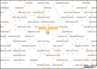
Mān Lūngmi (Shan, Myanmar)Mān Lūngmi is a town in the Shan region of Myanmar. An overview map of the region around Mān Lūngmi is displayed below.
regional and 3d topo map of Mān Lūngmi, Myanmar ::
Mān Lūngmi airports ::
The nearest airport is LSH - Lashio, located 110.5 km south west of Mān Lūngmi.
Other airports nearby include MYT - Myitkyina (227.2 km north west), Nearby towns ::
Wān Hsiensha (1.7km east) //
Mān Nawngsang (3.7km north) //
Mān Tak (3.9km north west) //
Mān Tünmong (4.1km south west) //
Mān Nawnghiu (4.1km north west) //
Mān Panghkem (5.1km west) //
Wān Ko-tou (5.4km east) //
Wān Li-tzu-shan (5.4km east) //
Wān Ko-mong (5.4km east) //
Mān Kawng Song (5.8km south) //
Mān Wengtang (5.8km north) //
Wān Mingshan (6.3km south east) //
Mān Loi-kang (6.3km north west) //
Mān Lao-lai (6.5km south east) //
Mān Nanwa (6.5km north east) //
Mān Heng (7.4km south) //
Wān Pao-chu (6.8km east) //
Mān Hō-la (7.0km west) //
Wān Ma-chang (7.0km east) //
Mān Kawngkaw (7.6km south) //
Mān Namtawng (7.6km north) //
Mān Nawnghkam (7.5km south west) //
Mān Loi-kang (7.5km north west) //
Mān Wa-sü-sai (8.2km north west) //
Mān Hoi (8.2km south east) //
Mān Nawngsang (8.8km south west) //
Wān Hkawngkawshu (9.0km south east) //
Mān Nawnghkam (8.8km south west) //
Wān Niu-chang (8.8km north east) //
[all distances 'as the bird flies' and approximate] 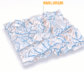 Places with similar names to Mān Lūngmi, Myanmar :: Disclaimer :: Information on this page comes without warranty of any kind |
||
|
Where is Mān Lūngmi? Elevation and coordinates ::
Latitude (lat): 23°39'0"N Longitude (lon): 98°33'0"E
Elevation (approx.): 1151m (map arrows pan, magnifying glasses zoom) |
||
|
Visiting Mān Lūngmi? Hotel/Accommodation ::
Book a hotel in Mān Lūngmi Travel Guide ::
Buy a travel guide for Myanmar rental cars ::
car rental offers GPS waypoint ::
download a GPX waypoint (PoI) of Mān Lūngmi for your GPS receiver
|
||