|
search place name
|
||
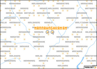
Mān Nawnghkam (Shan, Myanmar)Mān Nawnghkam is a town in the Shan region of Myanmar. An overview map of the region around Mān Nawnghkam is displayed below.
regional and 3d topo map of Mān Nawnghkam, Myanmar ::
Mān Nawnghkam airports ::
The nearest airport is LSH - Lashio, located 101.7 km south west of Mān Nawnghkam.
Other airports nearby include MYT - Myitkyina (228.4 km north west), Nearby towns ::
Mān Nawngsang (0.0km north) //
Mān Nawnghkam (1.7km east) //
Mān Nawng (3.4km west) //
Mān Hō-la (3.7km north) //
Mān Nawnghpai (3.9km north west) //
Mān Hsai-hkao (3.9km south west) //
Mān Hsai-hkao (5.0km south west) //
Mān Lomhkawng (5.1km west) //
Mān Tünmong (5.4km east) //
Mān Kawngkaw (5.4km east) //
Mān Panghkem (5.8km north) //
Möng Paw (5.8km south) //
Mān Mao (5.8km south) //
Mān Loi Hseng (6.3km north west) //
Mān Hō-pūng (6.5km south west) //
Mān Ho-et (7.0km west) //
Mān Pū-hsi-htao (7.6km north) //
Mān Heng (7.0km east) //
Mān Namhsam (7.5km south east) //
Mān Kawng-hka (8.2km north west) //
Mān Tak (8.2km north east) //
Mān Pinghkūm (9.0km north west) //
Mān Lūngmi (8.8km north east) //
Mān Kawnghkam (9.0km south east) //
Mān Pangsung (9.0km south east) //
Mān Tōn-lōm (10.1km north west) //
Mān Nawnghkiu (10.1km south east) //
[all distances 'as the bird flies' and approximate]  Places with similar names to Mān Nawnghkam, Myanmar ::
// Mān Nawnghkam (MM)
// Mān Nawnghkam (MM)
Disclaimer :: Information on this page comes without warranty of any kind |
||
|
Where is Mān Nawnghkam? Elevation and coordinates ::
Latitude (lat): 23°36'0"N Longitude (lon): 98°29'0"E
Elevation (approx.): 1060m (map arrows pan, magnifying glasses zoom) |
||
|
Visiting Mān Nawnghkam? Hotel/Accommodation ::
Book a hotel in Mān Nawnghkam Travel Guide ::
Buy a travel guide for Myanmar rental cars ::
car rental offers GPS waypoint ::
download a GPX waypoint (PoI) of Mān Nawnghkam for your GPS receiver
|
||