|
search place name
|
||
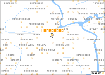
Mān Pāngma (Shan, Myanmar)Mān Pāngma is a town in the Shan region of Myanmar. An overview map of the region around Mān Pāngma is displayed below.
regional and 3d topo map of Mān Pāngma, Myanmar ::
Mān Pāngma airports ::
The nearest airport is LSH - Lashio, located 95.4 km south west of Mān Pāngma.
Nearby towns ::
Mān Pangwo (1.9km south) //
Mān Pangsa-kāng (3.4km east) //
Ho-li (4.1km north east) //
Mān Pangsa (3.9km north east) //
Mān Kawng-ngai (3.9km south east) //
Mān Loi-hkam (5.0km north west) //
Mān Loi-pe (5.0km south west) //
Mān Pāngsa-nö (5.0km south east) //
Mān Hoi (5.1km west) //
Mān Kawnghūng (5.4km east) //
Mān Pangmakket (5.8km south) //
Mān Ping-ye (5.8km north) //
Mān Tōngkep (5.8km north) //
Mān Hu-lum (5.8km north) //
Mān Panglūm (5.8km south) //
Mān Hpaktu (6.5km south west) //
Mān Nawnglong (6.3km north west) //
Mān Kawnghsa (6.5km south east) //
Mān Hpa-hpüng (6.3km south west) //
Mān Panglü (6.8km east) //
Mān Nawnglūm (7.6km north) //
Mān Pang-yao (7.1km east) //
Mān Hkamten-tau (7.1km east) //
Mān Hkamten-no (7.7km south east) //
Mān Loi-hkam (7.7km south east) //
Mān Kawnglong (8.8km south west) //
Kunlong (8.8km north east) //
Mān Ping (10.1km south west) //
Mān Kangmöng (10.1km south west) //
[all distances 'as the bird flies' and approximate] 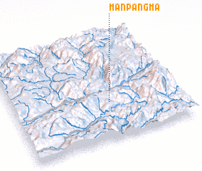 Places with similar names to Mān Pāngma, Myanmar ::
// Mān Pangmao (MM)
Disclaimer :: Information on this page comes without warranty of any kind |
||
|
Where is Mān Pāngma? Elevation and coordinates ::
Latitude (lat): 23°22'0"N Longitude (lon): 98°35'0"E
Elevation (approx.): 971m (map arrows pan, magnifying glasses zoom) |
||
|
Visiting Mān Pāngma? Hotel/Accommodation ::
Book a hotel in Mān Pāngma Travel Guide ::
Buy a travel guide for Myanmar rental cars ::
car rental offers GPS waypoint ::
download a GPX waypoint (PoI) of Mān Pāngma for your GPS receiver
|
||