|
search place name
|
||
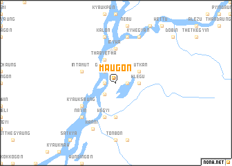
Ma-ugon (Sagaing, Myanmar)Ma-ugon is a town in the Sagaing region of Myanmar. An overview map of the region around Ma-ugon is displayed below.
regional and 3d topo map of Ma-ugon, Myanmar ::
Ma-ugon airports ::
The nearest airport is LSH - Lashio, located 180.5 km south east of Ma-ugon.
Other airports nearby include MYT - Myitkyina (198.3 km north east), Nearby towns ::
Mè-hin (1.7km west) //
Indaung (1.7km east) //
Kyettagaung (2.5km south west) //
Gwegôn (2.5km north west) //
Hlegu (3.4km east) //
Thabyetha (4.1km north west) //
Hlutkan (3.9km north east) //
Inywa (5.6km north) //
Shwebôhtha (5.6km north) //
Tantabin (5.6km south) //
Wègyi (5.8km south) //
Intamut (5.4km west) //
Kyauksaung (6.3km south west) //
Setyongon (7.6km north) //
Kalôn (7.6km north) //
Aleywa (7.6km north) //
Nat-in (7.5km south west) //
Kanni (8.2km south west) //
Kywègyan (8.2km north east) //
Pyinlebin (8.2km north east) //
[all distances 'as the bird flies' and approximate] 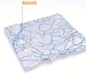 Places with similar names to Ma-ugon, Myanmar ::
Disclaimer :: Information on this page comes without warranty of any kind |
||
|
Where is Ma-ugon? Elevation and coordinates ::
Latitude (lat): 23°53'0"N Longitude (lon): 96°17'0"E
Elevation (approx.): 93m (map arrows pan, magnifying glasses zoom) |
||
|
Visiting Ma-ugon? Hotel/Accommodation ::
Book a hotel in Ma-ugon Travel Guide ::
Buy a travel guide for Myanmar rental cars ::
car rental offers GPS waypoint ::
download a GPX waypoint (PoI) of Ma-ugon for your GPS receiver
|
||