|
search place name
|
||
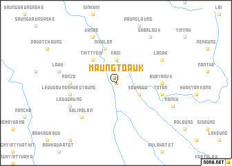
Maungto Auk (Shan, Myanmar)Maungto Auk is a town in the Shan region of Myanmar. An overview map of the region around Maungto Auk is displayed below.
regional and 3d topo map of Maungto Auk, Myanmar ::
Maungto Auk airports ::
The nearest airport is HEH - Heho, located 123.8 km north of Maungto Auk.
Nearby towns ::
Maungto Atet (0.0km north) //
Maungto (0.0km north) //
Kagi (3.7km north) //
Saungdu (4.0km south east) //
Thittyeik (5.1km north west) //
Nikalon (5.8km north) //
Ponzo (7.0km west) //
Bubya Auk (7.0km east) //
Ledugaung Shwegyaung (7.2km west) //
Totan (7.2km east) //
Salipalan (7.6km south west) //
Ledugaung (7.9km south west) //
Kanbe (8.2km north west) //
Lagaw (7.9km north east) //
Sabalauk (9.1km north east) //
[all distances 'as the bird flies' and approximate] 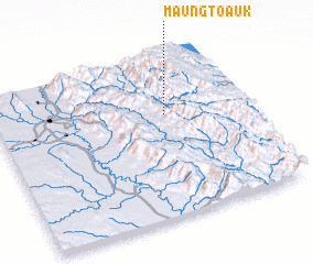 Places with similar names to Maungto Auk, Myanmar ::
// Mān Katkau (MM)
// Manokotak (US)
// Menikhtaíika (GR)
// Mangatoka (MG)
// Mangatoka (MG)
// Mangoudougou (BF)
// Mingteke (KG)
// Manak Deki (PK)
// Manga Doga (PK)
// Mangadougou (GN)
Disclaimer :: Information on this page comes without warranty of any kind |
||
|
Where is Maungto Auk? Elevation and coordinates ::
Latitude (lat): 19°38'0"N Longitude (lon): 96°41'0"E
Elevation (approx.): 677m (map arrows pan, magnifying glasses zoom) |
||
|
Visiting Maungto Auk? Hotel/Accommodation ::
Book a hotel in Maungto Auk Travel Guide ::
Buy a travel guide for Myanmar rental cars ::
car rental offers GPS waypoint ::
download a GPX waypoint (PoI) of Maungto Auk for your GPS receiver
|
||