|
search place name
|
||
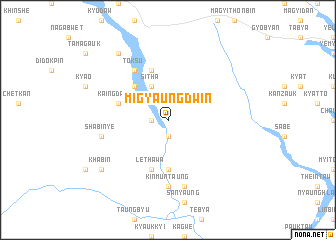
Migyaungdwin (Myanmar)Migyaungdwin is a town in Myanmar. An overview map of the region around Migyaungdwin is displayed below.
regional and 3d topo map of Migyaungdwin, Myanmar ::
Migyaungdwin airports ::
The nearest airport is MDL - Mandalay Intl, located 141.3 km east of Migyaungdwin.
Other airports nearby include AKY - Sittwe (228.6 km south west), KYP - Kyaukpyu (239.6 km south west), Nearby towns ::
Kyaunggon (1.7km west) //
Kyunyin (1.9km south) //
Sitha (4.1km north west) //
Natha (5.1km north west) //
Ledaing (5.6km south) //
Lethawa (5.8km south) //
Sulegon (5.8km north) //
Kaingdawye (5.5km west) //
Toksu (6.5km north west) //
Kinmuntaung (7.4km south) //
Shabinyè (7.2km west) //
Myithpya (7.6km south) //
Khabin (8.9km south west) //
Nyaungwun (9.0km north west) //
[all distances 'as the bird flies' and approximate] 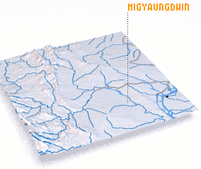 Places with similar names to Migyaungdwin, Myanmar ::
// Migyaungdwin (MM)
Disclaimer :: Information on this page comes without warranty of any kind |
||
|
Where is Migyaungdwin? Elevation and coordinates ::
Latitude (lat): 21°18'0"N Longitude (lon): 94°41'0"E
Elevation (approx.): 115m (map arrows pan, magnifying glasses zoom) |
||
|
Visiting Migyaungdwin? Hotel/Accommodation ::
Book a hotel in Migyaungdwin Travel Guide ::
Buy a travel guide for Myanmar rental cars ::
car rental offers GPS waypoint ::
download a GPX waypoint (PoI) of Migyaungdwin for your GPS receiver
|
||