|
search place name
|
||
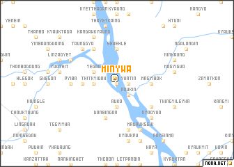
Minywa (Sagaing, Myanmar)Minywa is a town in the Sagaing region of Myanmar. An overview map of the region around Minywa is displayed below.
regional and 3d topo map of Minywa, Myanmar ::
Minywa airports ::
The nearest airport is MDL - Mandalay Intl, located 84.9 km east of Minywa.
Other airports nearby include HEH - Heho (206.1 km south east), Nearby towns ::
Kanbyu (0.0km north) //
Anein (1.9km north) //
Kaing (1.9km north) //
Tawgyaung (1.7km east) //
Ywatin (1.7km east) //
Paukin (2.5km south east) //
Thitkyidaw (3.4km west) //
Auko (3.7km south) //
Yedaw (3.9km north west) //
Pyiba East (5.2km west) //
Shwehle (5.6km north) //
Magyibok (5.2km east) //
Danbingan (5.8km south) //
Nyaungbingaing (6.5km north west) //
Shwepan (6.4km south east) //
Pyiba (6.9km west) //
Mauale (7.6km south) //
Taunggya (7.6km north west) //
Kyaoywa (7.6km south east) //
Kandawkyaung (8.2km north west) //
Phyaukseikpin (7.8km north west) //
Laungshe (7.8km north west) //
Mauaukseik (8.2km south east) //
[all distances 'as the bird flies' and approximate] 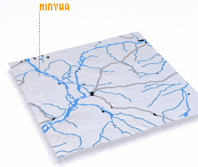 Places with similar names to Minywa, Myanmar ::
Disclaimer :: Information on this page comes without warranty of any kind |
||
|
Where is Minywa? Elevation and coordinates ::
Latitude (lat): 21°49'0"N Longitude (lon): 95°10'0"E
Elevation (approx.): 62m (map arrows pan, magnifying glasses zoom) |
||
|
Visiting Minywa? Hotel/Accommodation ::
Book a hotel in Minywa Travel Guide ::
Buy a travel guide for Myanmar rental cars ::
car rental offers GPS waypoint ::
download a GPX waypoint (PoI) of Minywa for your GPS receiver
|
||