|
search place name
|
||
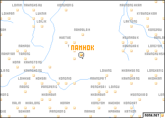
Namhok (Shan, Myanmar)Namhok is a town in the Shan region of Myanmar. An overview map of the region around Namhok is displayed below.
regional and 3d topo map of Namhok, Myanmar ::
Namhok airports ::
The nearest airport is LSH - Lashio, located 56.1 km north of Namhok.
Other airports nearby include MDL - Mandalay Intl (191.5 km south west), HEH - Heho (211.1 km south west), MOG - Mong Hsat (275.2 km south east), Nearby towns ::
Mān Maü (1.7km west) //
Ton-sam (2.5km north west) //
Hpa-hkö (4.1km north west) //
Hwe-twe (5.0km north west) //
Nam-pa-lam (5.6km north) //
Namhkam (5.8km south) //
Namhtam (5.8km south) //
Loi-wing (6.3km south east) //
Kongnio (6.5km south west) //
Hsawngke (6.5km south west) //
Nawngpat (6.5km south east) //
Nawnghi (7.1km west) //
Hsai-le (7.6km south west) //
Penghsai (8.2km south east) //
Hongleng (9.0km south east) //
Pangpeng (10.1km south west) //
Kongnyawng (10.1km south east) //
Loi-ngu (10.1km south east) //
Nawnglom (10.1km south east) //
[all distances 'as the bird flies' and approximate] 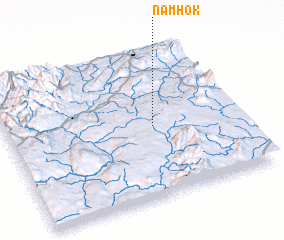 Places with similar names to Namhok, Myanmar ::
Disclaimer :: Information on this page comes without warranty of any kind |
||
|
Where is Namhok? Elevation and coordinates ::
Latitude (lat): 22°29'0"N Longitude (lon): 97°38'0"E
Elevation (approx.): 828m (map arrows pan, magnifying glasses zoom) |
||
|
Visiting Namhok? Hotel/Accommodation ::
Book a hotel in Namhok Travel Guide ::
Buy a travel guide for Myanmar rental cars ::
car rental offers GPS waypoint ::
download a GPX waypoint (PoI) of Namhok for your GPS receiver
|
||