|
search place name
|
||
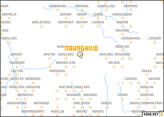
Nawnghkio (Shan, Myanmar)Nawnghkio is a town in the Shan region of Myanmar. An overview map of the region around Nawnghkio is displayed below.
regional and 3d topo map of Nawnghkio, Myanmar ::
Nawnghkio airports ::
The nearest airport is HEH - Heho, located 105.9 km south west of Nawnghkio.
Other airports nearby include MDL - Mandalay Intl (158.4 km west), LSH - Lashio (171.4 km north), MOG - Mong Hsat (211.4 km south east), Nearby towns ::
Pangmaileng (1.9km north) //
Wān Hkai (2.5km south west) //
Panglaw (2.5km south west) //
Ngammöng (2.5km north west) //
Pawhpoi (2.5km north east) //
Nawng Hwi (3.4km west) //
Kong Long (3.4km west) //
Wān Mak Leng (3.9km south west) //
Hko Hpai Mai (3.9km north west) //
Nawng Hwi (3.9km north west) //
Pāngkaw (3.9km north west) //
Pan Mau (5.1km south west) //
Nemlang (5.2km east) //
Pong Hkok (6.4km south west) //
Hputan (6.9km west) //
Makman (7.4km north) //
Konglang (7.4km south) //
Pongya Hsai (7.1km west) //
Kōnghkok (7.6km south) //
Kalöng (7.1km east) //
Hkoyawp (8.2km south west) //
Wan Pa-men (8.2km north west) //
Kunniu (8.2km north east) //
Loi-wēng (8.2km north east) //
Wān Nam Maw Loi (9.0km south west) //
[all distances 'as the bird flies' and approximate] 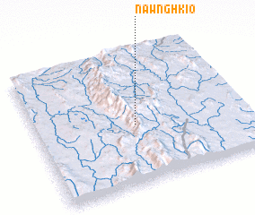 Places with similar names to Nawnghkio, Myanmar ::
Disclaimer :: Information on this page comes without warranty of any kind |
||
|
Where is Nawnghkio? Elevation and coordinates ::
Latitude (lat): 21°27'0"N Longitude (lon): 97°29'0"E
Elevation (approx.): 1649m (map arrows pan, magnifying glasses zoom) |
||
|
Visiting Nawnghkio? Hotel/Accommodation ::
Book a hotel in Nawnghkio Travel Guide ::
Buy a travel guide for Myanmar rental cars ::
car rental offers GPS waypoint ::
download a GPX waypoint (PoI) of Nawnghkio for your GPS receiver
|
||