|
search place name
|
||
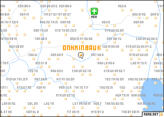
Onhminbauk (Shan, Myanmar)Onhminbauk is a town in the Shan region of Myanmar. An overview map of the region around Onhminbauk is displayed below.
regional and 3d topo map of Onhminbauk, Myanmar ::
Onhminbauk airports ::
The nearest airport is HEH - Heho, located 11.1 km north of Onhminbauk.
Other airports nearby include MDL - Mandalay Intl (142.4 km north west), Nearby towns ::
Inni (1.9km south) //
Taungthu (1.9km north) //
Myetset (1.9km north) //
Kanbani (1.7km west) //
Taungbogyi (2.5km south west) //
Natdaw (3.5km east) //
Chaunggya (3.7km south) //
Bawninyodaw (3.7km north) //
Myindwin (4.1km south east) //
Mawnang (3.9km north east) //
Momaka (5.2km east) //
Kandan (5.2km west) //
Ingaung (5.6km north) //
Ye-nge (5.6km north) //
Pawlamaw (5.5km east) //
Nyaungbin Ashe (5.5km east) //
Intha (5.5km east) //
Pawdok (6.4km south west) //
Ponzin (6.6km north east) //
Htinyugon (6.6km south west) //
Myethonzon (6.6km north west) //
Htanaungbin (6.9km west) //
Thitetit (7.4km south) //
Nyaunggyat (7.6km north) //
Ngonthon (7.2km west) //
Paya-u (7.6km south) //
Kyauksin (7.6km south) //
Taya (7.6km north) //
Kyaukhnget (7.9km south east) //
[all distances 'as the bird flies' and approximate] 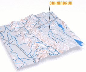 Places with similar names to Onhminbauk, Myanmar :: Disclaimer :: Information on this page comes without warranty of any kind |
||
|
Where is Onhminbauk? Elevation and coordinates ::
Latitude (lat): 20°39'0"N Longitude (lon): 96°46'0"E
Elevation (approx.): 1255m (map arrows pan, magnifying glasses zoom) |
||
|
Visiting Onhminbauk? Hotel/Accommodation ::
Book a hotel in Onhminbauk Travel Guide ::
Buy a travel guide for Myanmar rental cars ::
car rental offers GPS waypoint ::
download a GPX waypoint (PoI) of Onhminbauk for your GPS receiver
|
||