|
search place name
|
||
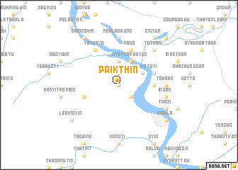
Paikthin (Myanmar)Paikthin is a town in Myanmar. An overview map of the region around Paikthin is displayed below.
regional and 3d topo map of Paikthin, Myanmar ::
Paikthin airports ::
The nearest airport is KYP - Kyaukpyu, located 165.3 km south west of Paikthin.
Other airports nearby include SNW - Thandwe (186.6 km south west), HEH - Heho (205.4 km north east), MDL - Mandalay Intl (213.4 km north east), Nearby towns ::
Gyaywa (0.0km north) //
Teindaw (1.9km north) //
Kondan (2.5km south east) //
Nyaungbintha (2.5km south east) //
Nyaungbintha-anauk (2.5km south east) //
Kanni (3.7km north) //
Kyetnapakyun (4.1km north east) //
Kyunbyatgyi (3.9km north east) //
Myenu (3.9km north east) //
Myingun (5.2km east) //
Thetyindaw (5.5km east) //
Yengan (5.5km west) //
Pado (5.8km north) //
Yathaya (6.6km north west) //
Mehladaung (7.4km north) //
Toksan (7.0km east) //
Ingon (7.2km east) //
Tatkon (7.6km north east) //
Thazi (7.9km south east) //
Zigyun (9.1km north east) //
Saingshin (9.1km north west) //
Nandawgon (9.1km north west) //
Lebingyin (8.9km south west) //
Minhla (8.9km south east) //
Pokkon (10.2km north east) //
[all distances 'as the bird flies' and approximate] 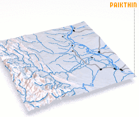
Disclaimer :: Information on this page comes without warranty of any kind |
||
|
Where is Paikthin? Elevation and coordinates ::
Latitude (lat): 20°1'0"N Longitude (lon): 94°59'0"E
Elevation (approx.): 46m (map arrows pan, magnifying glasses zoom) |
||
|
Visiting Paikthin? Hotel/Accommodation ::
Book a hotel in Paikthin Travel Guide ::
Buy a travel guide for Myanmar rental cars ::
car rental offers GPS waypoint ::
download a GPX waypoint (PoI) of Paikthin for your GPS receiver
|
||