|
search place name
|
||
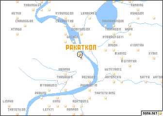
Pakatkon (Sagaing, Myanmar)Pakatkon is a town in the Sagaing region of Myanmar. An overview map of the region around Pakatkon is displayed below.
regional and 3d topo map of Pakatkon, Myanmar ::
Pakatkon airports ::
The nearest airport is IMF - Imphal, located 103.0 km north west of Pakatkon.
Other airports nearby include IXS - Silchar (195.3 km west), AJL - Aizwal Aizawl (213.3 km west), Nearby towns ::
Minya (0.0km north) //
Zibyugon (2.5km north west) //
Thayaung (2.5km north east) //
Dochon (4.1km north west) //
Manmaw (5.0km south west) //
Tunkaing (5.0km north west) //
Sanda (5.6km north) //
Zinbyungon (5.6km north) //
Thetkegyin (5.4km east) //
Pozagon (5.8km south) //
Ye-e-gyaung (6.5km north west) //
Thadagon (6.5km south west) //
Paungbyin (7.6km south) //
Ondok (7.0km east) //
Zaungkalaw (7.6km north) //
Segyaung (8.1km south west) //
Settaw (8.1km north west) //
Letpantha (8.1km north west) //
Wutkyaing (7.7km south east) //
Myebaunggyi (7.7km north east) //
Nandaw (9.0km north east) //
Wayontha (8.7km south east) //
Tawmagon (8.7km north east) //
Intabaung (10.0km south west) //
Naungmakauk (10.0km north east) //
[all distances 'as the bird flies' and approximate]  Places with similar names to Pakatkon, Myanmar ::
// Paço Tucano (BR)
Disclaimer :: Information on this page comes without warranty of any kind |
||
|
Where is Pakatkon? Elevation and coordinates ::
Latitude (lat): 24°20'0"N Longitude (lon): 94°48'0"E
Elevation (approx.): 118m (map arrows pan, magnifying glasses zoom) |
||
|
Visiting Pakatkon? Hotel/Accommodation ::
Book a hotel in Pakatkon Travel Guide ::
Buy a travel guide for Myanmar rental cars ::
car rental offers GPS waypoint ::
download a GPX waypoint (PoI) of Pakatkon for your GPS receiver
|
||