|
search place name
|
||
Panatnge (Myanmar)Panatnge is a town in Myanmar. An overview map of the region around Panatnge is displayed below.
regional and 3d topo map of Panatnge, Myanmar ::

Panatnge airports ::
The nearest airport is MGZ - Myeik, located 49.4 km north west of Panatnge.
Other airports nearby include HHQ - Prachuap Khiri Khan Hua Hin (119.8 km north east), BKK - Bangkok Intl (263.9 km north east), Nearby towns ::
Salo (1.8km west) //
Tonnwe (2.6km south west) //
Zalun (3.7km south) //
Awgyi (4.1km south east) //
Kawmapyin (4.1km south east) //
Mayingyi (4.1km south east) //
Mawton (4.1km south west) //
Mawton (4.1km south west) //
Banlamut (4.1km north west) //
Kandaw (4.1km north west) //
Aukkyun (5.8km south) //
Anaukkahtaing (6.6km south west) //
Yanhpo (6.6km north west) //
Phinu (7.5km west) //
Hpani (7.6km north) //
Thittat (8.3km north east) //
Pawachaungwa (8.1km south west) //
Kadaw (8.3km south west) //
Kyaukpyu (9.2km north east) //
Mayingyigan (9.2km south east) //
Tanintharyi (9.2km south east) //
Sindin (9.2km north west) //
Watha (9.2km south west) //
Sadeinthaung (10.4km south east) //
Kadwenauk (10.4km north west) //
Hpebyin (10.4km north west) //
Peindaw (10.4km south west) //
[all distances 'as the bird flies' and approximate] 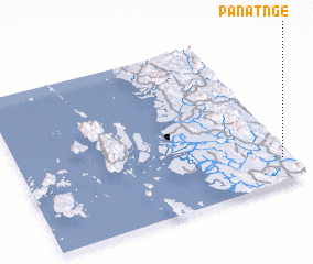 Places with similar names to Panatnge, Myanmar :: Disclaimer :: Information on this page comes without warranty of any kind |
||
|
Where is Panatnge? Elevation and coordinates ::
Latitude (lat): 12°9'0"N Longitude (lon): 98°58'0"E
Elevation (approx.): 191m (map arrows pan, magnifying glasses zoom) |
||
|
Visiting Panatnge? Hotel/Accommodation ::
Book a hotel in Panatnge Travel Guide ::
Buy a travel guide for Myanmar rental cars ::
car rental offers GPS waypoint ::
download a GPX waypoint (PoI) of Panatnge for your GPS receiver
|
||