|
search place name
|
||
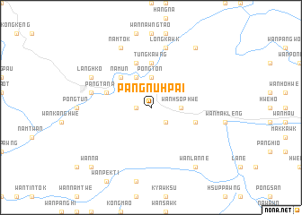
Pāngnu-hpai (Shan, Myanmar)Pāngnu-hpai is a town in the Shan region of Myanmar. An overview map of the region around Pāngnu-hpai is displayed below.
regional and 3d topo map of Pāngnu-hpai, Myanmar ::
Pāngnu-hpai airports ::
The nearest airport is MOG - Mong Hsat, located 124.5 km east of Pāngnu-hpai.
Other airports nearby include HEH - Heho (142.8 km west), THL - Tachilek Tachileik (194.2 km east), KET - Kengtung (195.0 km north east), Nearby towns ::
Namhu (1.7km west) //
Mawnla (1.7km west) //
Wān Pu-kè (2.5km south east) //
Pongton (3.7km north) //
Wān Hsophwe (3.5km east) //
Pukam (4.1km north west) //
Wān Tamongkai (5.1km north west) //
Nam-un (5.1km north west) //
Tüngkawng (5.6km north) //
Pāngken (5.8km north) //
Pangtā-nawng (5.5km west) //
Wān Hsa-wa (5.5km east) //
Wān Makkawk (5.5km east) //
Longtan (7.2km west) //
Hatmaü (7.6km north) //
Longkawk (7.6km north) //
Langhko (7.9km north west) //
Namtok (8.2km north west) //
Ho-hwè-hkun (9.1km north east) //
Wān Lanne (9.1km south east) //
Wān Nā (10.2km south west) //
Namhsa-ning (10.2km south west) //
[all distances 'as the bird flies' and approximate] 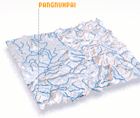 Places with similar names to Pāngnu-hpai, Myanmar ::
// Ping'anpu (CN)
Disclaimer :: Information on this page comes without warranty of any kind |
||
|
Where is Pāngnu-hpai? Elevation and coordinates ::
Latitude (lat): 20°19'0"N Longitude (lon): 98°5'0"E
Elevation (approx.): 1075m (map arrows pan, magnifying glasses zoom) |
||
|
Visiting Pāngnu-hpai? Hotel/Accommodation ::
Book a hotel in Pāngnu-hpai Travel Guide ::
Buy a travel guide for Myanmar rental cars ::
car rental offers GPS waypoint ::
download a GPX waypoint (PoI) of Pāngnu-hpai for your GPS receiver
|
||