|
search place name
|
||
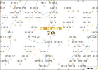
Pang Nyim (Shan, Myanmar)Pang Nyim is a town in the Shan region of Myanmar. An overview map of the region around Pang Nyim is displayed below.
regional and 3d topo map of Pang Nyim, Myanmar ::
Pang Nyim airports ::
The nearest airport is HEH - Heho, located 68.5 km west of Pang Nyim.
Other airports nearby include MDL - Mandalay Intl (185.7 km north west), MOG - Mong Hsat (190.1 km east), Nearby towns ::
Wān Keng (1.9km north) //
Pang Nyim (1.7km east) //
Hkailong (1.7km east) //
Wan-sa Man (2.5km south west) //
Möngkawk (3.7km north) //
Konlin (3.7km south) //
Wān Lè (4.1km north east) //
Hwe-lai (4.1km north east) //
Hko-heng (5.1km south east) //
Pet-yanglon (5.5km west) //
Hwè-lon (5.5km west) //
Sipsi (5.8km north) //
Longhkaw (6.4km north east) //
Ho-sem (6.6km north west) //
Wān Keng (6.6km south west) //
Nam Hu (6.6km south west) //
Pa-keng (6.9km west) //
Nawnglwin (7.4km south) //
Nawngwop (7.4km north) //
Bān Ping (6.9km west) //
Namkak (7.2km east) //
Namsa-wo (7.2km east) //
Longlawt (7.2km east) //
Kong-yang (7.6km north) //
Wān Sam (7.6km south) //
Möng Pawn (7.6km north) //
Wan Mak Ka (7.6km south west) //
Longpeng (7.9km north east) //
Kawngyau (7.9km south east) //
[all distances 'as the bird flies' and approximate]  Places with similar names to Pang Nyim, Myanmar ::
// Pang Nyim (MM)
Disclaimer :: Information on this page comes without warranty of any kind |
||
|
Where is Pang Nyim? Elevation and coordinates ::
Latitude (lat): 20°45'0"N Longitude (lon): 97°27'0"E
Elevation (approx.): 1084m (map arrows pan, magnifying glasses zoom) |
||
|
Visiting Pang Nyim? Hotel/Accommodation ::
Book a hotel in Pang Nyim Travel Guide ::
Buy a travel guide for Myanmar rental cars ::
car rental offers GPS waypoint ::
download a GPX waypoint (PoI) of Pang Nyim for your GPS receiver
|
||